Tag: PAR

Tropical Storm “Khanun” expected to enter PAR on Saturday or Sunday; to be named “Falcon”

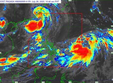
  (Eagle News) — Tropical Storm “Khanun” is forecast to enter the Philippine Area of Responsibility between late Saturday evening and Sunday morning, the Philippine Atmospheric Geophysical and Astronomical Services Administration said on Friday, July 28. According to PAGASA, once it enters PAR, it will be assigned the name “Falcon.” So far, “Khanun” is located1,345 km east of Eastern Visayas, packing maximum sustained winds of 65 kph near the center and a gustiness of up […]

Tropical Depression “Caloy” exits PAR

(Eagle News) — Tropical Depression “Caloy” is now outside the Philippine Area of Responsibility. According to the Philippine Atmospheric Geophysical and Astronomical Services Administration, the center of “Caloy” was estimated 575 km west of Iba, Zambales and is moving westward slowly. It is packing maximum sustained winds of 55 kph near the center and a gustiness of up to 70 kph. PAGASA said in the next 24 hours, the monsoon trough and the southwest monsoon […]

Tropical cyclone wind signals raised over parts of Luzon as “Maring” moves to exit PAR

(Eagle News) — Tropical cyclone wind signals remain hoisted over parts of Luzon with Severe Tropical Storm “Maring” about to exit the Philippine Area of Responsibility. The Philippine Atmospheric Geophysical and Astronomical Services Administration said the following areas are under Signal No. 2, as “Maring” moves over 315 kilometers west of Calayan, Cagayan: Batanes Cagayan including Babuyan Islands the northern portion of Isabela (Palanan, Divilacan, Maconacon, Ilagan City, Tumauini, Cabagan, San Pablo, Santa Maria, Santo […]

“Emong” exits PAR

(Eagle News) — “Emong” is now outside the Philippine Area of Responsibility. According to the Philippine Atmospheric Geophysical and Astronomical Services Administration, “Emong” slightly weakened and is now situated 335 km northwest of Itbayat, Batanes. It is packing maximum sustained winds of 45 kph near the center, gustiness of up to 55 kph, with a central pressure of 1004 hPa. It is moving northwestward at 20 kph, with strong winds extending outwards up to 200 […]

“Bising” exits PAR

(Eagle News) — “Bising” has left the Philippine Area of Responsibility. The Philippine Atmospheric Geophysical and Astronomical Services Administration said “Bising,” now a tropical storm,” left PAR at 5:40 a.m. on Sunday, April 25. Metro Manila and the rest of the country, however, are expected to have partly cloudy to cloudy skies with isolated rain showers. Flash floods or landslides during severe thunderstorms are possible. According to the weather bureau, the northern and eastern sections […]

Tropical depression enters PAR; “Auring” now first cyclone to hit PHL in 2021

(Eagle News) — The tropical depression off Mindanao has entered the Philippine Area of Responsibility and is now named “Auring.” The Philippine Atmospheric Geophysical and Astronomical Services Administration said “Auring”  is officially the first cyclone to enter PAR in 2021. It is so far not affecting any part of the country but localities in the Visayas, Bicol Region, MIMAROPA, Caraga, Northern Mindanao, Davao Region, Cotabato, and Lanao del Sur, especially hazard-prone areas, were advised to […]

PAGASA: “Siony” may intensify into severe tropical storm in next 24 to 36 hours

(Eagle News)–“Siony” is expected to intensify into a severe tropical storm in the next 24 to 36 hours. The Philippine Atmospheric Geophysical and Astronomical Services Administration made the forecast as it announced the tropical storm has slightly intensified as it moved slowly over the Philippine Sea east of extreme Northern Luzon. So far, it is estimated 565 km east of Basco, Batanes, packing maximum sustained winds of 85 kph near the center and gustiness of […]

PAGASA: Cloud cluster east of PAR may become LPA or tropical disturbance

(Eagle News)–The Philippine Atmospheric Geophysical and Astronomical Services Administration is monitoring a cloud cluster east of the Philippine Area of Responsibility that may become a tropical disturbance or a low pressure area. In a recent weather update, weather forecaster Raymond Ordinario said the southwest monsoon was affecting Palawan and Visayas. Batanes, Cagayan and the Batanes Island Group are expected to have  cloudy skies with scattered rains. He said the rest of Luzon including Metro Manila […]

“Leon” exits PAR

(Eagle News)–Tropical Storm “Leon” has exited the Philippine Area of Responsibility. The Philippine Atmospheric Geophysical and Astronomical Services Administration said “Leon,” with international name “Noul,” exited PAR at 3 a.m. today, and has continued to maintain its strength. So far, it is located 360 kilometers northwest of Kalayaan Islands, packing maximum sustained winds of 85 kilometers per hour near the center and gustiness of up to 105 kph. It is moving west northwest at 15 […]

“Ursula” slightly weakens; is forecast to exit PAR on Saturday, Dec. 28

(Eagle News) — “Ursula” has slightly weakened as it moved over the West Philippine Sea on Thursday, Dec. 26. The Philippine Atmospheric Geophysical and Astronomical Services Administration said Signal No. 1, however, is still hoisted over the northwestern portion of Occidental Mindoro including Lubang Island (Lubang, Looc, Paluan, Abra de Ilog, Mamburao) and Calamian Islands (Coron, Culion, Busuanga), as “Ursula,” situated 235 km northwest of Coron, Palawan, packing maximum sustained winds of up to 120 […]

JUST IN: Tropical Depression “Marilyn” enters PAR

(Eagle News)–The tropical depression monitored by the Philippine Atmospheric Geophysical and Astronomical Services Administration has entered the Philippine Area of Responsibility. PAGASA said TD “Marilyn” entered PAR at 9:30 a.m. The weather bureau earlier said  CALABARZON, Bicol Region, MIMAROPA, Visayas, Zamboanga Peninsula, Aurora, Quirino, Isabela, and Cagayan will experience  cloudy skies with scattered to widespread rainshowers as the trough of the tropical depression affects Southern Luzon and Visayas. Metro Manila and the rest of the […]

Tropical Storm Ineng now out of PHL, moving over Taiwan Strait

  (Eagle News) – Tropical storm “Ineng” has already left the Philippine Area of Responsibility (PAR) and is now moving over the Taiwan Strait towards Southeastern China. “Ineng exited the PAR at 6:00 PM today,” said PAGASA in its latest weather bulletin. “All Tropical Cyclone Wind Signals have been lifted. However, gusty conditions will still prevail over most of Luzon, especially over Northern Luzon, due to the Southwest Monsoon,” it said. Ineng has accelerated and […]