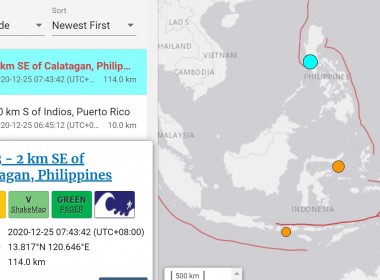
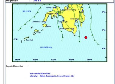
(Eagle News) – A magnitude 6.3 quake rocked Batangas province on Friday morning, Dec. 25, at 7:43 a.m. local time, data from the US Geological Survey showed. The epicenter of the magnitude 6.3 quake was located at two kilometers southeast of Calatagan, Batangas. It had a depth of 114 kilometers, according to the USGS data. The Philippine Institute of Volcanology and Seismology (PHIVOLCS), also recorded it at magnitude 6.3, but its epicenter was located […]
Tag: USGS
Magnitude 7 quake hits Papua New Guinea
A strong magnitude 7 quake shook Papua New Guinea on Friday, July 17, sending residents scrambling from buildings in the capital Port Moresby but there were no immediate reports of damage or casualties. The quake was 79.8 kilometers deep and its epicenter was located 114 kilometers north northwest of Popondetta, Papua New Guinea, the US Geological Survey said. It was located in a remote region near the eastern coast around 150 kilometres from Port […]
Magnitude 5.8 shakes New Zealand’s north island
(Eagle News) – A magnitude 5.8 quake shook New Zealand’s North Island at 7:53 a.m. local time in New Zealand (3:53 a.m. Manila time), according to GeoNet which provides geological hazard information for New Zealand. The quake was registered at 5.6 by the US Geological Survey (USGS) GeoNet said that quake was located 30 kilometers northwest of Levin, which is the largest town and seat of the Horowhenua District, in the Manawatū-Whanganui region […]
Magnitude 6.4 quake hits desert area on Nevada-California border followed by several aftershocks
A 6.4 magnitude earthquake struck Friday, May 15, in a sparsely populated desert area on the border between Nevada and California, and has been followed by several aftershocks, according to the US Geological Survey. The quake hit at 4:03 am local time (1103 GMT) about 40 miles (60 kilometers) from the small, former mining town of Tonopah, Nevada, which is about halfway between Las Vegas and Reno. It had a depth of about […]
Magnitude 6.9 quake shakes Kurilsk, Russia
(Eagle News) — A magnitude 6.9 quake shook Kuril’sk, a town in Russia, on Thursday, Feb. 13, at UTC 10:33 or 6:33 p.m. Manila time. The quake was 142.6 kilometers deep and its epicenter was recorded 92 kilometers east northeast of Kuril’sk, Russia, according to the United States Geological Service (USGS). It is also located 370.1 kilometers southwest of Nemuro, Hokkaido, Japan. There were no immediate reports of damage.
Magnitude 7.7 quake hits Caribbean, triggering evacuations; tremors felt as far as US mainland
MIAMI, United States (AFP) — A major 7.7 magnitude quake struck Tuesday in the Caribbean between Jamaica and Cuba, triggering a brief tsunami alert and sending hundreds of people pouring onto the streets of Havana. The tremors were felt as far as the US mainland as police in Miami evacuated some buildings as a precaution. The US Geological Survey said the quake hit at a depth of 10 kilometers (six miles), at 1910 GMT — […]
New Zealand shaken by series of magnitude 5.1 and 5.3 quakes, says USGS data
(Eagle News) – New Zealand was rocked by a series of quakes – specifically two magnitude 5.1 and magnitude 5.3 tremors – according to data from the US Geological Survey (USGS). The shaking was felt starting 10:45 a.m. (UTC time) of Jan. 25 (6:45 pm Manila time), measuring magnitude 5.1 which occurred 50 kilometers northwest of Paraparaumu with a depth of 86.2 kilometers, followed by a magnitude 5.3 quake occurring 162 kilometers south southeast […]
PHIVOLCS seeks help from int’l scientists, borrows infrared camera from US to view Taal’s main crater
(Eagle News) — The Philippine Institute of Volcanology and Seismology (PHIVOLCS) is talking with the United States Geological Service (USGS) regarding the ongoing volcanic activity of Taal Volcano, seeking their help to better get accurate data and images on the restive volcano’s crater. The US embassy is also securing an infrared camera to be used by PHIVOLCS to take pictures of Taal’s main crater. Ma. Antonia Bornas, chief of the Volcano Monitoring Division of PHIVOLCS, […]
Magnitude 6.5 earthquake hits off Puerto Rico: USGS
WASHINGTON, United States (AFP) — A strong earthquake struck off the south of Puerto Rico early Tuesday, the US Geological Survey said, the latest in a series of tremors that have shaken the island since December 28. The shallow 6.5 magnitude quake struck 13.6 kilometers (8.5 miles) south of the city of Ponce, USGS said, revising down its initial reading of 6.6. The quake struck just off the US territory’s southern Caribbean coastline at […]
Magnitude 5.4 quake rocks Davao Occidental
(Eagle News) – A magnitude 5.4 quake shook Davao Occidental on Wednesday, September 18, at 3 p.m., with its epicenter located 136 kilometers southeast of Sarangani town. The Philippine Institute of Volcanology and Seismology (PHIVOLCS) said the quake was of tectonic origin. It had a depth of focus of 24 kilometers. The United States Geological Survey also monitored the quake which it recorded at magnitude 5.5. The USGS located the quake’s epicenter 112 kilometers […]
6.3-magnitude earthquake rocks Indonesia’s Papua
A 6.3-magnitude earthquake hit Papua, in eastern Indonesia Thursday, US seismologists said, but no tsunami warning was issued. The quake hit about 250 kilometres west of the town of Abepura in Papua province at 12:46 am local time, at a depth of 12 kilometres, according to the US Geological Survey. The quake was felt weakly in Abepura, but most people did not notice it. “I was still awake at home but I did not […]
Magnitude 6.4 quake hits New Zealand
(Eagle News) – A magnitude 6.4 quake struck New Zealand, with the epicenter traced at 140 kilometers northeast of L’Esperance Rock, Wednesday, 3 p.m. Manila time. According to the United States Geological Survey, the quake had a depth of 10 kilometers. The quake was around 909 kilometers from Ngunguru, Northland, New Zealand. It was recorded at 7:01 a.m. UTC time (Coordinated Universal Time). L’Esperance Rock is the southernmost islet in the Kermadec Islands, to […]


