Tag: Philippine Area of Responsibility

Typhoon “Malakas” enters PAR

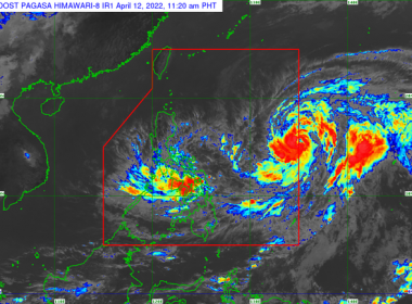
(Eagle News) — Typhoon “Malakas” has entered the Philippine Area of Responsibility. According to the Philippine Atmospheric Geophysical and Astronomical Services Administration, “Malakas,” now with local name “Basyang,” entered PAR at 10 a.m. The center of the eye of the typhoon was so far located 1,435 km east of Southern Luzon, packing maximum sustained winds of 120 kph near the center, and a gustiness of up to 150 kph. The typhoon is moving north northwestward at […]

LPA southeast of Palau intensifies into tropical depression; may enter PAR on Tuesday

(Eagle News) — The low pressure area southeast of Palau and outside the Philippine Area of Responsibility has intensified into a tropical depression. According to the Philippine Atmospheric Geophysical and Astronomical Services Administration, it may enter PAR on Tuesday. It will be named “Odette” if this happens, the weather bureau said. According to PAGASA, the weather disturbance is expected to make landfall over the Eastern Visayas-Caraga area, based on its forecast track. So far, it […]

PAGASA: Cloud cluster east of PAR may become LPA or tropical disturbance

(Eagle News)–The Philippine Atmospheric Geophysical and Astronomical Services Administration is monitoring a cloud cluster east of the Philippine Area of Responsibility that may become a tropical disturbance or a low pressure area. In a recent weather update, weather forecaster Raymond Ordinario said the southwest monsoon was affecting Palawan and Visayas. Batanes, Cagayan and the Batanes Island Group are expected to have  cloudy skies with scattered rains. He said the rest of Luzon including Metro Manila […]

“Ursula” slightly weakens; is forecast to exit PAR on Saturday, Dec. 28

(Eagle News) — “Ursula” has slightly weakened as it moved over the West Philippine Sea on Thursday, Dec. 26. The Philippine Atmospheric Geophysical and Astronomical Services Administration said Signal No. 1, however, is still hoisted over the northwestern portion of Occidental Mindoro including Lubang Island (Lubang, Looc, Paluan, Abra de Ilog, Mamburao) and Calamian Islands (Coron, Culion, Busuanga), as “Ursula,” situated 235 km northwest of Coron, Palawan, packing maximum sustained winds of up to 120 […]

“Wutip” intensifies into a typhoon; remains outside PAR

(Eagle News) — The Philippine Atmospheric Geophysical and Astronomical Services Administration is still monitoring a weather disturbance outside the Philippine Area of Responsibility as it intensified into a typhoon on Friday, Feb. 22. PAGASA said “Wutip” intensified from a severe tropical storm as of 3 a.m., and was located 2400 kilometers east of Mindanao. It is packing maximum sustained winds of up to 130 kilometers per hour near the center, and gustiness of up to […]

LPA enters Philippine area of responsibility

(Eagle News)—A low pressure area has entered the Philippine Area of Responsibility. The Philippine Atmospheric Geophysical and Astronomical Services Administration said the LPA entered PAR at 10 a.m. PAGASA said it would issue a weather advisory at noon for more details.  

PAGASA: Typhoon “Tomas” now out of PAR but is forecast to re-enter within next 12 to 24 hours

(Eagle News)–Typhoon “Tomas” has moved out of the Philippine Area of Responsibility but is expected to re-enter within the next 12 to 24 hours. As of 10 a.m., the center of the typhoon was 1,445 kilometers east of Aparri, Cagayan, packing maximum sustained winds of up to 145 kilometers per hour near the center and gustiness of up to 180 kilometers per hour. “Tomas” is moving north northeast at 15 kilometers per hour. According to […]

TD “Samuel” leaves PAR

(Eagle News) — Tropical Depression “Samuel” is now outside the Philippine Area of Responsibility. The Philippine Atmospheric Geophysical and Astronomical Services Administration said “Samuel” left PAR at 6 p.m. and is now heading towards the direction of southern Vietnam. “This weather disturbance is no longer affecting any part of the country,” PAGASA said. According to PAGASA, sea travel, however, is “risky” over the seaboards of northern Luzon because of the surge of the northeast monsoon.

“Paeng” exits PAR

  (Eagle News)—Typhoon “Paeng” is now outside the Philippine Area of Responsibility. In its 7:30 a.m. bulletin on Saturday, Sept. 29, the Philippine Atmospheric Geophysical and Astronomical Services Administration said the eye of the typhoon was located 730 kilometers northeast of Basco, Batanes, outside PAR. PAGASA said “Paeng” no longer has any direct effect on the country. Sea travel in the northern and eastern seaboards of Luzon, however, remains risky, PAGASA said.  

“Paeng” to exit PAR on Saturday, Sept. 29

(Eagle News) — “Paeng” is moving slowly in a northwestward direction and is expected to exit the Philippine Area of Responsibility on Saturday, Sept. 29, the Philippine Atmospheric Geophysical and Astronomical Services Administration said. In its 11 a.m. advisory, PAGASA said as of 10 a.m., the eye of Typhoon “Paeng” was located  655 kilometers east northeast of Basco, Batanes. The typhoon is packing maximum sustained winds of up to 160 kilometers per hour near the center and […]

“Trami” intensifies as it heads toward Taiwan

(Eagle News)–“Trami” continues to intensify  on Monday, Sept. 24, as it moves  west northwest toward Taiwan. As of 1 a.m., the eye of “Paeng,” as it is locally called, was located 1100 kilometers east of Tuguegarao. The typhoon is packing maximum sustained winds of 170 kilometers per hour near the center and gustiness of up to 210 kilometers per hour, moving at 20 kilometers per hour. It may exit the Philippine Area of Responsibility on […]

PAGASA: “Trami” enters PAR but has no direct effect on PHL so far

(Eagle News)–Typhoon “Trami” entered the Philippine Area of Responsibility on Sunday, but has no direct effect so far on the country. The Philippine Atmospheric Geophysical and Astronomical Services Administration said “Trami,” which is now called “Paeng,” entered PAR at 10:30 a.m. As of 4 p.m., its eye was located 1290 kilometers east of Tuguegarao. “Paeng” is packing maximum sustained winds of up to 125 to 155 kilometers per hour, and is moving west at 20 […]