


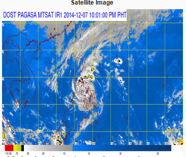
(Eagle News Service) — Typhoon Ruby is expected to make its third landfall Monday, Dec. 8, between 2 a.m. and 4 a.m., in Sibuyan island as it moved west northwest at 10 kilometers per hour. As of 7 p.m., it is located 50 kilometers northwest of Masbate City, with maximum winds of 140 kilometers per hour near the center and gustiness of up to 170 kph.
The country’s weather bureau, PAGASA, said typhoon Ruby is expected to exit the Philippine Area of Responsibility Thursday morning.
The typhoon will still bring strong winds and heavy to torrential rainfall when it slams into Sibuyan island Monday early morning. It could also bring in storm surges, PAGASA said.
Its estimated amount of rainfall is from 10 to 30 millimeters per hour, which means heavy to torrential rains, within the 500 kilometers of the typhoon.
By Monday afternoon, it is forecast to be 160 kilometers South of the Science Garden in Quezon City, PAGASA said.
Public storm warning signal number 3 is hoisted over Masbate,Ticao Island, Burias Island, Marinduque, Romblon, Oriental Mindoro.
Winds of up to100 to 185 kph is expected in at least 18 hours. Residents in low-lying and mountainous areas are alerted against flashfloods and landslides. Likewise, those living along the coast are warned on the occurrence of big waves associated with storm surge which may reach up to three meters.
Public storm warning signal number 2 is hoisted over Sorsogon, Albay, Cavite, Laguna, Batangas, Lubang Island, Quezon, Occidental Mindoro, Camarines Norte and Camarines Sur in Luzon; and in Northern Samar, Samar, Biliran, Aklan, Capiz, Northern Cebu including Cebu City, Bantayan Island and Camotes Island in the Visayas region.
Winds of 61 to 100 kph is expected in these areas in at least 24 hours.
Residents in low-lying and mountainous areas are alerted against possible flashfloods and landslides. Likewise, those living along the coast are warned on the occurrence of big waves associated with Storm Surge which may reach up to 2 meters, PAGASA’s severe weather bulletin issued at 5 p.m. said.
At least 10 provinces in Luzon were placed under storm signal number one. They are Zambales, Bataan
Nueva Ecija, Tarlac, Pampanga, Bulacan, Metro Manila, Rizal, Catanduanes and Northern Palawan. At least nine areas in Visayas are also under signal number 1: Iloilo, Antique, Guimaras, Negros Occidental, Negros Oriental, Eastern Samar, Leyte, Southern Leyte and the rest of Cebu.
Typhoon “Ruby” and the northeast monsoon will cause rough to very rough sea conditions over the seaboards of Luzon and Visayas and over the northern seaboard of Mindanao. Fisherfolk and those using small sea craft are advised not to venture out over the said seaboards, PAGASA said.


