


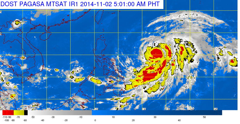
MANILA, Philippines — Typhoon “Paeng”, the latest weather disturbance to enter the country, was spotted 1,220 kilometers east of Baler, Aurora as of 4:00 am today. It is expected to move west northwest at 13 kph.
Typhoon “Paeng” (international name: Nuri) has maximum sustained winds of 120 kph near the center and gustiness of up to 150 kph. The current Northeast Monsoon is also affecting Northern Luzon.
PAGASA said the Bicol region, Eastern Visayas, Northern Mindanao, CARAGA and the provinces of Palawan, Batangas and Quezon will have cloudy skies with light to moderate rainshowers and thunderstorms.
Cagayan Valley, Cordillera and Ilocos region will exprience partly cloudy skies with isolated light rains. Metro Manila and the rest of the country will be partly cloudy to cloudy with isolated rainshowers or thunderstorms.
Moderate to strong winds blowing from the northeast will prevail over Luzon and Eastern Visayas and the coastal waters along these areas will be moderate to rough. Elsewhere, winds will be light to moderate coming from the northwest to west with slight to moderate seas.
OVER METRO MANILA:
Maximum Temperature: 1:50 PM Yesterday — 32.1°C
Minimum Temperature: 6:00 AM Yesterday — 23.8°C
Maximum Relative Humidity: 6:00 AM Yesterday — 98 %
Minimum Relative Humidity: 12:00 PM Yesterday — 67 %
Low Tide Today: 12:51 PM ….. 0.05 Meter
High Tide Today: 7:52 PM ….. 0.56 Meter
Low Tide Today: 11:55 PM ….. 0.46 Meter
Sunrise Today: 5:51 AM
Sunset Today: 5:27 PM
Moonrise Today: 1:49 PM
Moonset Tomorrow: 2:05 AM
Illumination Today: 71 %


