


 MANILA, Oct. 18 (PNA) – Stormy weather will prevail in the next 24 hours in most parts of Luzon, including Metro Manila, as typhoon “Lando” continues to move slowly toward the Cordillera and Ilocos regions, according to the Philippine Atmospheric, Geophysical and Astronomical Services Administration (PAGASA).
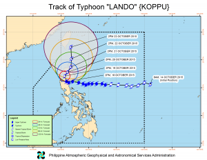
In an interview, PAGASA weather forecaster Aldczar Aurelio said that as of 4 p.m. Sunday, the eye of typhoon “Lando” was located based on all available data, including the the Subic Doppler radar, in the vicinity of Sta. Fe, Nueva Vizcaya (16.2N, 121.0E).
He said the typhoon’s maximum sustained winds near the center went down from 175 kilometers per hour (kph) on Sunday morning to 150 kph and its gustiness from 210 kph to 185 kph.
However, the typhoon slightly increased its speed from three kph to five kph as it moved west-northwest and continued to traverse the landmass of the Cordillera Administrative Region (CAR) and Isabela. It is expected to exit landmass in Cagayan by Wednesday morning.
With its slow movement, Aurelio said the typhoon will linger inside the country and is expected to exit the Philippine Area of Responsibility (PAR) on Saturday and head toward Japan.
Meanwhile, Public Storm Warning Signal No. 3 is raised over the provinces of Nueva Ecija, Quirino, Nueva Vizcaya, Benguet, Ifugao, Mountain Province, Kalinga, Ilocos Sur, La Union, Pangasinan and Zambales.
Signal No. 2 remains hoisted over Metro Manila, as well as in the provinces of Cagayan, including Calayan and Babuyan Group of Islands, Isabela, Aurora, Abra, Apayao, Ilocos Norte, Bataan, Tarlac, Pampanga, Bulacan, Rizal, and northern Quezon, including Polillo Islands.
Signal No. 1 is up in Batanes, Cavite, Laguna, Batangas and the rest of Quezon province.
Aurelio said that public storm warning signals elsewhere had been lowered.
Occasional rains and gusty winds will be experienced over provinces under PSWS #1, while those under PSWS #2 and #3 will have stormy weather. Residents in low-lying and mountainous areas of the provinces with PSWS are alerted against possible flash floods and landslides.
The estimated rainfall amount is from heavy to intense within the 600-km diameter of the typhoon.
Fisherfolk are advised not to venture out over the seaboards of Luzon and the Visayas
Aurelio said that weather improvement is expected in Southern Luzon, including Metro Manila, on Monday afternoon as typhoon “Lando” is headed toward extreme Northern Luzon.
He added that the typhoon is expected to make another landfall in extreme Northern Luzon by Thursday or Friday.
Typhoon “Lando” is forecast to be in the vicinity of Quirino, Ilocos Sur by Monday afternoon.
By Tuesday afternoon, it will be in the vicinity of Conner, Apayao and is expected to be at 40 km north-northeast of Aparri, Cagayan by Wednesday afternoon.
By Thursday afternoon, the cyclone is expected to be at 30 km south of Basco, Batanes and is forecast to be at 205 km north of Basco, Batanes by Friday afternoon.
In the next 24-hour forecast, PAGASA said that stormy weather is expected over Metro Manila, Ilocos Region, Cagayan Valley, Cordillera, Central Luzon and the province of Rizal and northern Quezon, including Polillo Islands, while rains with gusty winds will prevail over Batanes, Cavite, Laguna, Batangas and the rest of Quezon.
Cloudy skies with light to moderate rains will be experienced over the Visayas, Zamboanga Peninsula and the rest of Luzon, while partly cloudy to cloudy skies with isolated thunderstorms will prevail over the rest of Mindanao.
Moderate to strong winds blowing from the northeast to northwest will prevail over the rest of Luzon and coming from the southwest over the Visayas and Mindanao with moderate to rough seas.
The state-run weather bureau also issued a gale warning due to the effects of the typhoon as the sea condition would be rough to very rough due to strong to gale force winds expected to affect the seaboards of Luzon and the Visayas.
“Fishing boats and other small seacraft are advised not to venture out into the sea while larger sea vessels are alerted against big waves,” it warned. (PNA)
SCS/CLTC
-Christopher Lloyd T. Caliwan


