


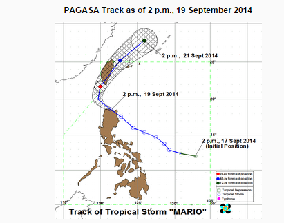
MANILA, Philippines — Tropical Storm “Mario” has slightly weakened while traversing the Babuyan Channel, PAGASA said.
As of 4 p.m., its location is at 70 kilometers northeast of Laoag City, with maximum winds of up to 75 kilometers per hour near the center and gustiness of up to 90 kilometers per hour. It is forecast to move west northwest at 19 kilometers per hour. It is forecast to leave the Philippine Area of Responsibility by Sunday afternoon, according to PAGASA.
As of 4 p.m., the provinces under storm signal number two are Cagayan, Cagayan including Calayan and Babuyan Group of Islands, Batanes Group of Islands, Apayao, and Ilocos Norte. Isabel, Kalinga, Mt. Province, Abra and Ilocos Sur are under signal number 1.
Public storm warning signals elsewhere are now lowered.
Residents in low lying and mountainous areas are alerted against possible flashfloods and landslides.
Estimated rainfall amount is from 7 – 20 mm per hour (moderate – intense) within the 350 km diameter of the Tropical Storm.
The combined effect of Southwest Monsoon and TS “MARIO” will bring moderate to heavy rains and thunderstorms in Metro Manila and the rest of Luzon which may trigger flashfloods and landslides.
Fisherfolks and those with small seacrafts are advised not to venture out over the western seaboard of northern Luzon, seaboards of southern and central Luzon and Visayas.


