


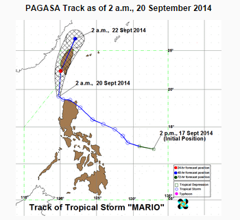
MANILA, Philippines (ENS) — Tropical storm “Mario” has slightly slowed down and intensified while moving over the Luzon Strait, but will likely leave the Philippine Area of Responsibility on Monday, the country’s weather bureau PAGASA said.
As of 4 am., the storm’s location was recorded 137 kilometers northwest of Laoag City, with maximum winds of 95 kilometers per hour near the center and gustiness of up to 120 kph. It is forecast to move North at 15 kph. By Sunday morning, it is expected to be 254 km Northwest of Itbayat, Batanes. Its exit from the Philippine Area of Responsibility will however be delayed, according to PAGASA. Instead of the previous forecast of Sunday afternoon, “Mario” is expected to be outside PAR by Monday morning, according to the latest weather forecast.
Public storm warning signal number two is still hoisted over the Calayan and Babuyan Group of Islands, Batanes Group of Islands, Apayao, and Ilocos Norte with winds of 61-100 kph is expected in at least 24 hrs. The provinces of Cagayan, Kalinga, Abra and Ilocos Sur are under signal number one. These areas will experience winds of 30 – 60 kph is expected in the next 36 hours.


