


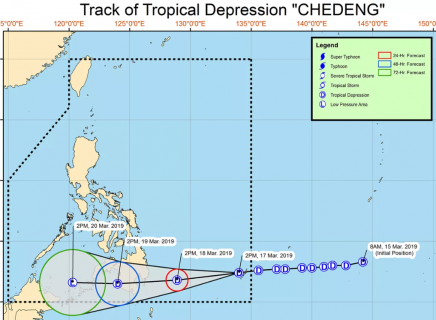
(Eagle News)–Signal No. 1 has been hoisted over Davao Oriental as Tropical Depression “Chedeng” entered the Philippine Area of Responsibility on Sunday, March 17.
The Philippine Atmospheric Geophysical and Astronomical Services Administration said Signal No. #1 may be raised over Davao del Norte and Compostela Valley in the next bulletin with “Chedeng,” which entered PAR around 11 a.m., expected to make landfall over the eastern coast of Davao Oriental between tomorrow evening and Tuesday morning.
As of 4 p.m., the center of the tropical depression was located 830 kilometers east of Hinatuan, Surigao del Sur, packing
maximum sustained winds of up to 45 km/h near the center and gustiness of up to 60 km/h.
“Chedeng” is moving westward at 25 km/h.
PAGASA said scattered to at times widespread moderate to heavy rains will prevail over Surigao del Sur, Agusan del Sur, Davao Oriental, Compostela Valley, and Davao del Norte tomorrow, March 18, and in most parts of Mindanao on Tuesday, March 19.
“The disaster risk reduction and management offices concerned and residents of these areas, especially those living in areas identified to be at high risk of flooding or landslide, are advised to undertake necessary preparations and continue monitoring for updates,” PAGASA said.
It said those with small seacrafts are advised not to venture out over the eastern seaboards of Visayas and Mindanao, as well as the seaboards of areas under Tropical Cyclone Warning Signal.


