


(Eagle News)–The tropical depression monitored near Mindanao is expected to enter the Philippine Area of Responsibility today, March 17.
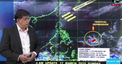
The Philippine Atmospheric Geophysical and Astronomical Services Administration said as of 3 a.m., the center of the weather disturbance was 1,175 kilometers east of southern Philippines.
It is packing maximum sustained winds of 45 km/h near the center and gustiness up to 60 km/h, as it moved west at 10 km/h.
Once it enters PAR, PAGASA said it will be named “Chedeng.”
Caraga and Davao Region will experience cloudy skies with scattered rainshowers and thunderstorms because of the trough of the tropical depression, with flash floods possible during severe thunderstorms.
PAGASA said Batanes, Cagayan and Isabela will have cloudy skies with light rains caused by the northeast monsoon affecting northern Luzon, while
Metro Manila and the rest of the country will have partly cloudy to cloudy skies with isolated rainshowers caused by localized thunderstorms.
Flash floods during severe thunderstorms are possible.


