


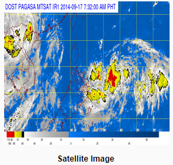
MANILA, Sept. 17 — Eastern Visayas, CARAGA and the Davao region will still experience cloudiness and some rains Wednesday as a low pressure area or LPA still hovers about a thousand kilometers east of the Visayas region, according to Philippine Atmospheric, Geophysical and Astronomical Services Administration (PAGASA)
as of 4 a.m .today, the LPA was estimated based on all available data at 1,070 km east of Visayas (13.2°N, 136.3°E).
Because of this Eastern Visayas, Caraga and Davao Region will have cloudy skies with light to moderate rains and thunderstorms. Metro Manila and the rest of the country will be partly cloudy to cloudy with isolated rainshowers or thunderstorms, stated PAGASA’s weather forecast for September 17.
Moderate to strong winds blowing from the southwest to south will prevail over the western section of Luzon and from the north to northwest over the rest of Luzon and Visayas and the coastal waters along these areas will be moderate to rough. Elsewhere, winds will be light to moderate coming from the southwest to west with slight to moderate seas.
The next tropical cyclone to enter the Philippine territory, he said, would be named “Mario” — the third cyclone to visit the country this month and 13th for the year.
Every year, an average of about 18 to 20 storms affect the Philippines, according to PAGASA.
The state weather bureau also issued a gale warning — strong to gale force winds associated with the surge of southwest monsoon affect the northern and western seaboards of Northern Luzon.
“Fishing boats and other small sea crafts are advised not to venture out into the sea while larger sea vessels are alerted against big waves,” it warned. (with reports from PNA)


