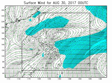
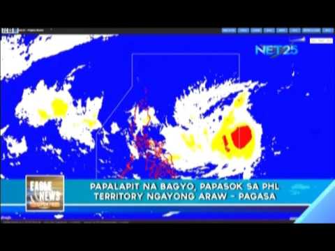
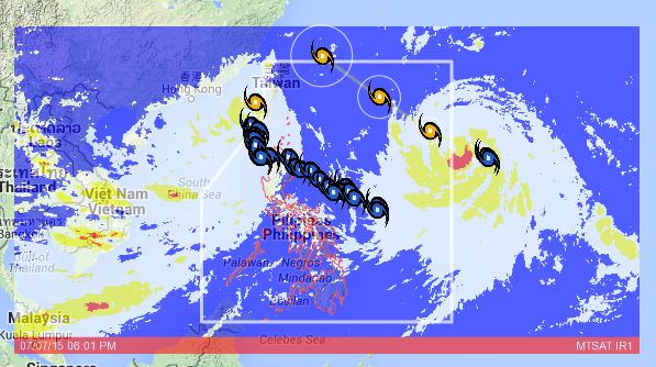
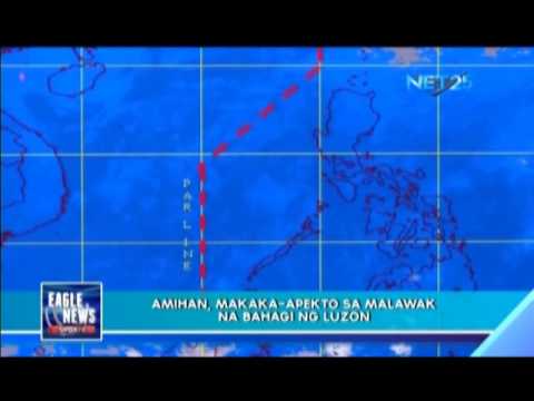
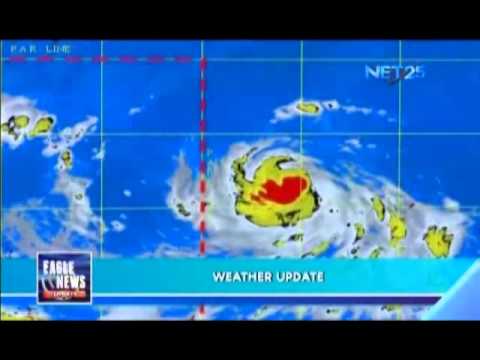
(Eagle News) — Lalo pang lumakas ang bagyo na binabantayan ng Philippine Atmospheric Geophysical and Astronomical Services Administration (PAGASA) sa labas ng Philippine Area of Responsibility (PAR). Ang bagyong may international name na “Sanvu” ay isa na ngayong severe tropical storm. Huli itong namataan sa dalawang libo limang daan at limampung kilometro (2,550 km) sa silangan hilagang silangan ng extreme northern Luzon. Taglay ng bagyo ang lakas ng hanging aabot sa isang daan at limang […]
Tag: PAR
Bagyong Bising, papalayo na sa bansa: posibleng lumabas sa PAR sa Miyerkules
QUEZON CITY, Philippines — Papalayo na sa bansa ang binabantayang bagyong Bising at posibleng lumabas sa Philippine Area Of Responsibility (PAR) sa susunod na 72 oras o sa araw ng Miyerkules. Ayon sa Philippine Atmospheric Geophysical and Astronomical Services Administration (PAGASA) , huling namataan ang sentro ng bagyo sa layong 415 kilometro east ng Guiuan, Eastern Samar. Taglay nito ang lakas ng hangin na 55 kph at pagbugsong 70 kph. Kumikilos ang tropical depression pa-hilaga […]
Typhoon Lawin further weakens, to exit PAR tonight
(Eagle News) – Typhoon Lawin again slightly weakened as it further traversed Apayao province, and is expected to exit the Philippine Area of Responsibility (PAR) Thursday night, October 20. Storm warning signals in Northern Luzon were further reduced in PAGASA’s latest weather bulletin issued at 8 a.m. As of 7 a.m., the eye of the typhoon was located 40 kilometers northwest of Laoag City, Ilocos Norte. It is forecast to move west northwest at […]
Bagyo, inaasahang papasok sa PAR sa Martes
Isang tropical depression ang mino-monitor ng PAGASA na inaasahang papasok sa bansa sa Martes.
“Lando” enters Philippine area of responsibility
The low pressure area (LPA) that the Philippine Atmospheric Geophysical and Astronomical Services Administration (PAGASA) has been monitoring this week has developed into a full tropical storm and given the designation “Lando”. The weather bureau said that if “Lando” will not change its course, it will make its landfall on northern Luzon. (Eagle News Service Described by Jay Paul Carlos, Video Editing by Jericho Morales, Uploaded by MRFaith Bonalos) https://youtu.be/6BA85HMp06w
LPA may enter PAR on Wednesday
The Philippine Atmospheric Geophysical and Astronomical Services Administration (PAGASA) is monitoring the progress of a low-pressure area that may enter the Philippine area of responsibility (PAR) on Wednesday. Said lower pressure area (LPA) may become a storm and will be designated “Lando”. (Eagle News Service Described by Jay Paul Carlos, Video Editing by Jericho Morales, Uploaded by MRFaith Bonalos)
PAGASA spots tropical storm outside PAR
The Philippine Atmospheric Geophysical and Astronomical Services Administration (PAGASA) is currently monitoring a tropical storm that the said weather bureau spotted outside of the Philippine area of responsibility. Said storm will strengthen the “habagat” bringing inclement weather in Visayas and Mindanao. (Eagle News) <em>(Eagle News Service Jay Paul Carlos, Jericho Morales, MRFaith Bonalos)</em>
Typhoon Ineng to be outside country Monday morning, leaves 14 people dead
(Eagle News) – Typhoon Ineng (international name: Goni) has maintained its strength as it continued to move away from the country, and is forecast to be outside the Philippine Area of Responsibility (PAR) by Monday morning. PAGASA said that as of 1 p.m. Sunday, Aug. 23, it was located 390 km northeast of Basco, Batanes. “Ineng” has maximum sustained winds of 140 kilometers per hour near the center and gustiness of up to 170 kph. […]
PAGASA monitoring 2 typhoons outside PAR; next storm to be named “Falcon” if it enters Phl
(Eagle News) — While storm “Egay” has already left the country, PAGASA is monitoring two new weather disturbances which are still outside the Philippine Area of Responsibility (PAR), but which could enter the country anytime this week. One of these is typhoon “Chan-Hom” (international name) which has maximum strong winds of 120 kilometers per hour near the center and gustiness of up to 150 kph. It is forecast to move west northwest at 20 kph. […]
PAGASA: Tropical storm to enter PAR by Tuesday
PAGASA said that from Tuesday to Wednesday (March 17-18), Tropical Storm Bavi is expected to enter the Philippine Area of Responsibility (PAR), but still generally fair weather condition will prevail throughout the whole archipelago apart from isolated rains in Luzon and isolated rains or localized thunderstorms in Visayas and Mindanao. The storm is to be locally codenamed Betty upon entering the PAR. PAGASA estimates the storm, based on its direction and speed, will enter the PAR […]
Potential storm looms in PH
The Philippine Atmospheric Geophysical and Astronomical Services Administration (PAGASA) is now eyeing a cluster of clouds forming outside the Philippine area of responsibility (PAR) that is expected to become a Low Pressure Area (LPA). PAGASA said yesterday that “It should become an LPA, it could enter the PAR and affect the country.” On the other hand, Northeast Monsoon will continue to affect the part of Luzon while the tail-end of a cold front affecting Eastern […]
New storm may enter PAR
“Ompong” may enter the Philippine area of responsibility(PAR) tomorrow, although said storm will not make a landfall.


