


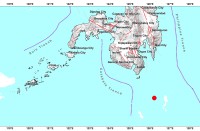
(Eagle News) — A low pressure area last spotted over Aurora has developed into a tropical depression, the Philippine Atmospheric, Geophysical and Astronomical Services said on Monday.
Pagasa said in its 5 p.m. bulletin that Tropical Depression “Kiko” was formed around 2 p.m., and that its center was last seen 490 kilometers east of Casiguran, Aurora.
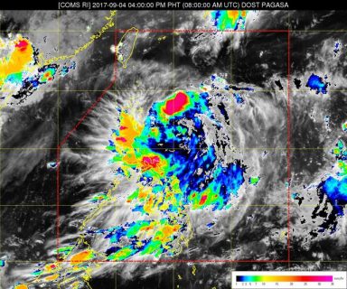
Kiko–which packs 55 kilometers per hour winds, and gusts of up to 65 kph— is the first typhoon in the country in September.
According to Pagasa, Kiko was moving west northwest, at a speed of 15 kph.
It will be closest to the Babuyan Group of Islands and Batanes on Wednesday morning.
Because Kiko has not developed an eye yet, Pagasa so far, there little possibility for it to make landfall.
The weather agency, however, does not remove the possibility it will.
Pagasa said moderate to heavy rains are expected from Tuesday in parts of northern Luzon.
The weather agency said a tropical cyclone warning signal no. 1 may be hoisted over the Babuyan Group of Islands and northern Cagayan on Monday night.
It said if Kiko continues with its west, northwest track, it is expected to leave the Philippine Area of Responsibility either on Wednesday afternoon or on Thursday.


