


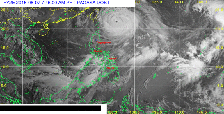
(Eagle News) — Typhoon “HANNA” (international name: Soudelor) continues to move closer towards the Batanes-Taiwan area as of Friday morning. PAGASA has already placed Batanes under storm warning signal number two while the Calayan and Babuyan group of islands are now under public storm signal number 1.
As of 4 a.m. Aug. 7, the eye of typhoon Hanna was located 485 km East Northeast of Itbayat, Batanes. It has maximum sustained winds of 165 kph near the center
and gustiness of up to 200 kph. Hanna is forecast to move West Northwest at 20 kph.
By Saturday morning, it is forecast to be 325 km North Northeast of Itbayat, Batanes. By Sunday morning, it is forecast to be already outside the Philippine Area of Responsibility (PAR) at 710 km Northwest of Itbayat, Batanes.
Batanes will experience winds of 61 to 120 kph which can cause light to moderate damage to high risk structures and very light to light damage to medium-risk structures, PAGASA said.Estimated rainfall amount is from moderate to heavy within the 700 km diameter of the typhoon. Fisher folk are advised not to venture out over the northern and eastern seaboards of Luzon, southern seaboard of Southern Luzon and the seaboards of Palawan, Visayas and Mindanao.
The Southwest Monsoon will continue to affect Southern Luzon, Visayas and Mindanao. Residents in low lying and mountainous areas are alerted against possible flashfloods and landslides.
After it exits the country, Hanna or Typhoon Soudelor is feared to bring heavy rainfall and damaging winds to Taiwan as it remains on a collision course with the island.
Although Soudelor has weakened, it remains a powerful typhoon and might gain strength and return to be being a supertyphoon before it makes landfall over Taiwan as it moves back to areas of warm ocean waters.
The Hong Kong observatory recently downgraded Soudelor from being a supertyphoon to a “severe typhoon” based on a South China Morning post report.


