Tag: Philippine Area of Responsibility

Typhoon approaches Philippine area of responsibility, Southwest monsoon affecting 6 provinces

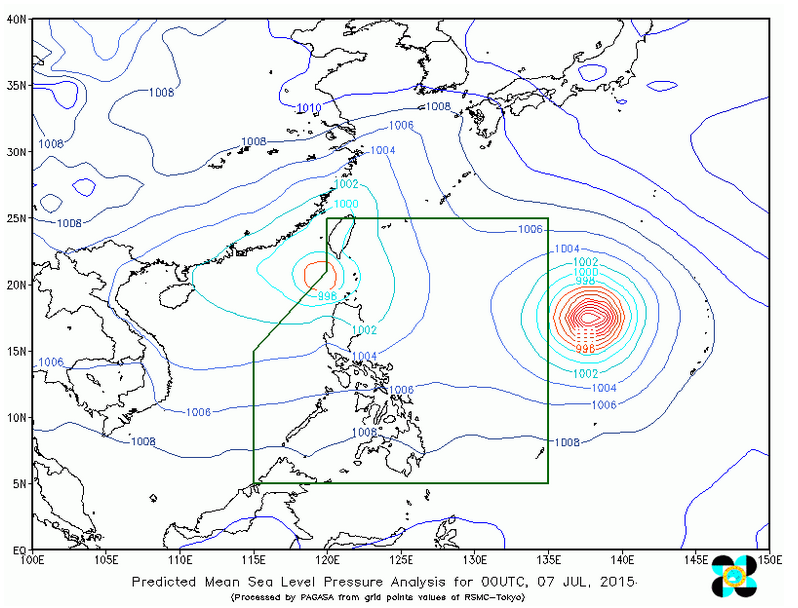
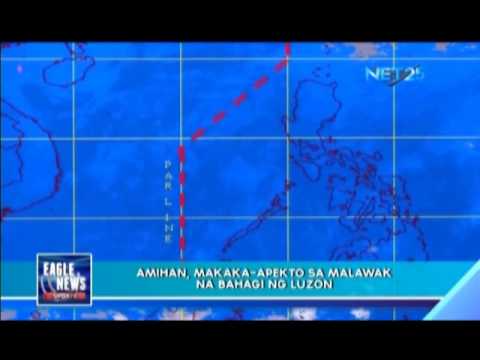
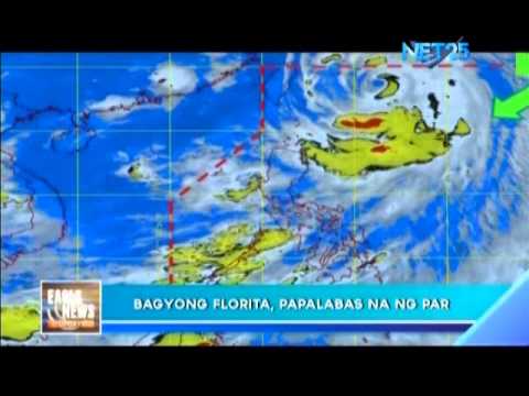
WEATHER Update, July 7 (PAGASA) — As of 10:00 am today, Typhoon “CHAN-HOM” (international name) outside the Philippine Area of Responsibility (PAR) was located based on all available data at 1,620 km east of Luzon (18.1°N, 137.0°E) with maximum sustained winds of 120 kph near the center and gustiness of up to 150 kph. It is forecast to move west northwest at 20 kph. This typhoon is expected to enter the PAR this afternoon or […]

Weather Update: Tropical Storm “Egay” is now outside the PAR

JULY 7 (PAGASA) — According to Philippine Atmospheric, Geophysical and Astronomical Services Administration (PAGASA), Tropical storm “Egay” is now outside the Philippine area of responsibility (PAR). At 8:00 AM today, the center of Tropical  Storm “EGAY”  was estimated based  on all available data at 320 km West  Southwest of  Basco, Batanes (20.3°N, 118.9°E). However, the southwest monsoon is still affecting Zambales, Bataan, Pangasinan, Benguet and Ilocos region, residents of these areas should be ready for […]

Typhoon outside the Philippine Area of Responsibility

At 5:00 am today, Typhoon “CHAN-HOM” (international name) outside the Philippine Area of Responsibility (PAR) was located based on all available data at 1,715 km east of Luzon  (17.8°N, 137.9°E) with maximum sustained winds of 120 kph near the center and gustiness f up to 150 kph. It is forecast to move west northwest at 20 kph. This typhoon is expected to enter the PAR this afternoon or evening (July 07) and will be named […]

Updated: “Egay” slows down as it heads for Northern Luzon; 4 areas under signal no. 1

UPDATED 6:30 p..m.  MANILA, Philippines, July 3 (Eagle News) — The weather bureau said on its Friday forecast that the tropical storm “Egay” has slightly intensified and slowed down while it continued to move closer to Northern Luzon. Egay has maximum sustained winds of 75 kilometers per hour near the center and gustiness of up to 90 kilometers per hour.  It is forecast to move west northwest at 10 kph. Earlier, the Philippine Atmospheric, Geophysical and […]

New storm may enter PAR

QUEZON City, Philippines, May 11 (Eagle News) — “Dodong” may be still within the Philippine area of responsibility (PAR) but the Philippine Atmospheric, Geophysical and Astronomical Services Administration (PAGASA) already spotted another storm nearing the PAR. Said storm will be given the name “Egay” once it enters the PAR. (Eagle News Service Jay Paul Carlos, Jericho Morales, MRFaith Bonalos)

Better prepare for Betty – Roxas tells local execs

PCOO – Interior and Local Government Secretary Mar Roxas called the attention of local chief executives in the Northeastern part of Luzon to prepare for typhoon “Betty.” As of last night, the typhoon with international name “Bavi” was already inside the Philippine Area of Responsibility (PAR), more than a thousand kilometers east of Casiguran, Aurora. It has strength of 65-80 kph, moving at 20 kph, and bringing light to moderate rains. With its current direction, […]

Potential storm looms in PH

The Philippine Atmospheric Geophysical and Astronomical Services Administration (PAGASA) is now eyeing a cluster of clouds forming outside the Philippine area of responsibility (PAR) that is expected to become a Low Pressure Area (LPA). PAGASA said yesterday that “It should become an LPA, it could enter the PAR and affect the country.” On the other hand, Northeast Monsoon will continue to affect the part of Luzon while the tail-end of a cold front affecting Eastern […]

PAGASA monitors LPA

PAGASA continues to monitor a low-pressure area in the Pacific Ocean, which will enter the Philippine area of responsibility. There’s a small chance of said LPA developing into a storm.