


ZURICH, Switzerland (Reuters) — With demand for drones booming, both for hobby and commercial use, the race is on to develop ever-more intelligent and autonomous systems. Getting drones, or unmanned aerial vehicles (UAVs), to effectively understand and interact with their environment has proved challenging.
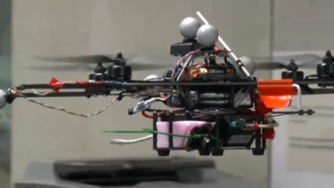
Researchers from the Vision for Robotics Lab at ETH Zurich are teaching drones how to ‘see’. They’ve created algorithms to give low-cost, off-the-shelf, drones the power to explore their environment and build a 3D map in the process, which they can use to plan a collision-free path and fulfill the mission’s requirements, such as industrial inspection or crop monitoring.
“We start off with zero knowledge about where the drone is,” explained Professor Margarita Chli (PRON: Schlee). “As soon as the autonomous mode is on the drone starts perceiving its environment, it starts building a map of its visual landmarks.”
This map serves as the basis of the drone’s understanding of space, which subsequently provides it with autonomous navigation capabilities.
Their UAV systems are equipped primarily with one camera and an inertial sensor, while the group is also experimenting with additional and different types of sensors, such as depth cameras used in the gaming industry. During a mission, a pre-determined goal is set, such as inspection of the facades of a particular building or navigation to a specific geographical marker, which the drone automatically plans its path to, while avoiding any obstacles encountered on the way; all the while scanning its surroundings and building a 3D map in real-time.
“The system is selecting what we call visual landmarks and judging how these landmarks move from one image to the next. Then the drone is really reasoning about its motion; essentially the motion of the camera,” said Chli.
Achieving a high level of scene perception from a moving and agile UAV platform is one of the main challenges the team is working to overcome. But a drone that can accurately map its environment in real-time could have important applications for autonomous aerial missions where being able to judge distance from obstacles would be crucial.
The team from Zurich says their system could give drones the ability to autonomously inspect disaster areas not accessible to humans.
“Drones can really offer a unique platform that is very agile and very fast in the environment. It really moves in 3D, so it can fly up and quickly gather the overview of, for example, a disaster area,” added Chli.
Using the sensors onboard the UAV the team is working to digitise the drone’s workspace in 3D. Known as real-time dense surface reconstruction, the team has demonstrated how two drones working together can fly around a statue while scanning to build an accurate 3D model. A possible application of this could be digitising archaeological sites, the team says.
Manufacturers increasingly see drones as a valuable new tool for tasks including remote inspection and search-and-rescue missions. UAVs have also recently been trialled to spot rhinoceros poachers in South Africa, and even to deliver pizzas and burgers in the United Kingdom.


