


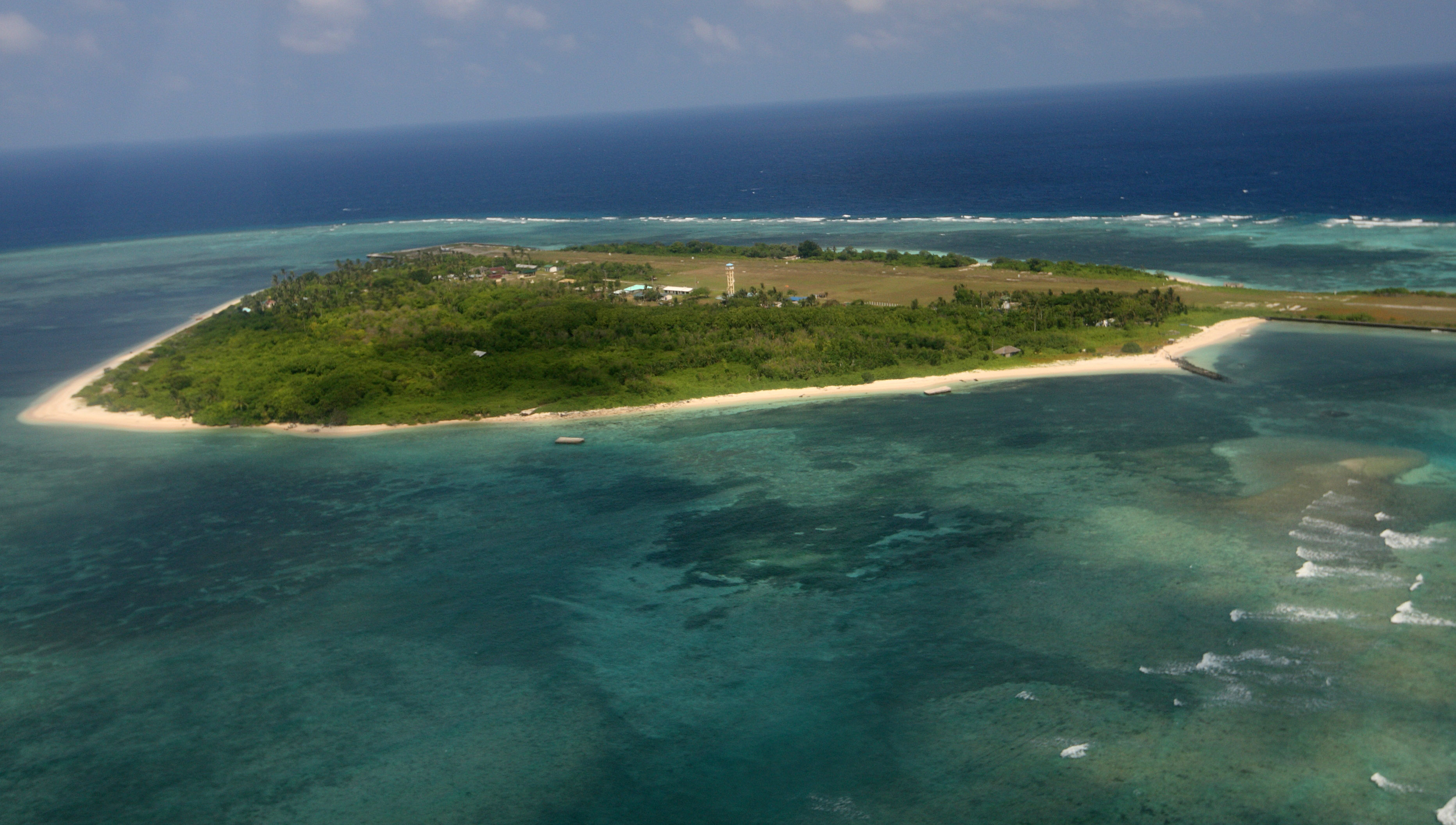
(Eagle News) — The Philippines’ recent construction work on Thitu Island (Pag-asa Island) has provoked a “paramilitary response” on the part of China, which has claims on the same as well, an American think-tank said in a recent report.
In its report published on Feb. 6, the Asia Maritime Transparency Initiative said China deployed a “large fleet of ships from Subi Reef, just over 12 nautical miles southwest” off the island after satellite imagery from Dec. 13 to Dec. 14 showed “a barge anchored off the west coast of the island with excavators and a bulldozer in the process of depositing and grading sand to extend the small existing causeway to the edge of the reef.”
The AMTI initially said this was “presumably” the beaching ramp Defense Seceretary Delfin Lorenzana previously announced the Philippines would build and will have completed by early 2019, but “more recent imagery” on Jan. 11 and 26, it said, showed that “the reclamation work is more ambitious” than this.
“Both images are partially obscured by clouds , but they reveal excavators depositing sand over an area of approximately 8 acres, or more than 32,000 square meters, to the north of the existing causeway,” the AMTI said, hinting that the work may have to do with what Lorenzana also said were Philippine plans to construct a fish port, a desalination plant, solar power array, improved housing facilities and marine research facilities on the island.
According to the AMTI, the ships China sent were from the People’s Liberation Army-Navy and from its coast guard, along with “dozens of fishing vessels ranging in size from 30 to 70 meters.”
Although there had been a “handful” of Chinese vessels operating between Subi and Thitu since at least July 2018, “likely in response to the initial Philippine effort to start runway repairs last May,” their numbers “increased to at least 24 on Dec. 3, just before the current construction operations began,” the AMTI said.
According to the think-tank, on Dec. 20, the ships reached a “high of 95” before dropping to 42 by Jan. 26.
The American think-tank said the “fishing boats have mostly been anchored between 2 and 5.5 nautical miles west of Thitu, while the naval and coast guard ships operate slightly farther away to the south and west.”
AMTI said this was “consistent with prior examples of China’s ‘cabbage strategy,’ which employs concentric layers of fishing, law enforcement and naval vessels around contested areas.”
China’s maritime militia
The AMTI said the fishing vessels “display all the hallmarks of belonging to China’s maritime militia,” as they, among others, had no gear in the water that would “indicate fishing activity and disabling their Automatic Identification System transceivers to hide their activities.”
The think-tank added two Chinese government vessels were seen in the Dec. 20 imagery—a PLAN Type 053H1G (Jianghu V-class) frigate and a CCG Type 818 (Zhaoduan class) cutter.
AMTI said the BRP Ramon Alcatraz, one of the Philippine Navy’s flagships, could also be seen in the imagery, over 7 miles from the PLAN frigate southeast of Thitu.
Although imagery from Jan. 11 showed one PLAN and CCG ship near Thitu, by Jan. 26, satellite imagery showed there was only a CCG Type 718B, the AMTI said.
It added the Ramon Alcatraz was not seen either.
“The drop in the number of government vessels, mirroring the reduction of the militia presence, suggests Chinese forces have settled into a pattern of monitoring and intimidation after their initial large deployment failed to convince Manila to halt construction,” AMTI said.


