


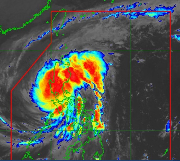
(Eagle News) — Typhoon “ULYSSES” (international name VAMCO) has moved inland and is now in the vicinity of southwestern Nueva Ecija as it further intensified with maximum winds of 155 kilometers per hour near the center and gusts of up to 255 km/hr, according to Philippine weather bureau, PAGASA.
At 4 a.m. today, Thursday, Nov. 12, the center of the eye of Typhoon “ULYSSES” was located based on all available data including those from Subic and Benguet Doppler Weather Radars in the vicinity of San Antonio, Nueva Ecija (15.3 °N, 120.8 °E ). It is moving West Northwestward at 25 km/h
With destructive winds and heavy to intense with at times torrential rainfall, the typhoon pummeled central and southern portions of Aurora, the northern portion of Quezon including Polillo Islands, Nueva Ecija, Bulacan, Tarlac, Pampanga, Pangasinan, Zambales, Bataan, Metro Manila, and Rizal. This will continue to be experienced within the next three hours, PAGASA said in its 5 a.m. bulletin.
Moderate to heavy damage to infrastructure and vegetation is expected.
-3 landfalls-
The typhoon intensified even after it made three landfalls. The first was in the vicinity of Patnanungan, Quezon around 10:30 p.m. Wednesday, Nov. 11 with destructive winds of 150 km/h near the center and gustiness of up to 205 km/h. The second landfall was in the vicinity of Burdeos, Quezon at 11:20 p.m. Its third landfall was in the vicinity of General Nakar, Quezon at 1:40 a.m. Thursday, Nov. 12.
But as of 4 a.m., the typhoons destructive winds even further intensified, with maximum sustained winds of 155 km/h near the center and gustiness of up to 255 km/h.
This was contrary to PAGASA’s earlier forecast that the typhoon would slightly weaken after it made its landfall.
-To cross Central Luzon landmass-
ULYSSES” will continue crossing the landmass of Central Luzon. The typhoon is forecast to emerge over the western seaboard of Zambales this morning. On the forecast track, the typhoon may exit the Philippine Area of Responsibility tomorrow morning or afternoon.
The very strong winds and torrential rains are associated with the region of inner rainbands and eyewall of the typhoon.
-NCR, 16 other provinces under Signal No. 3; destructive winds felt-
Metro Manila and 16 more provinces in Luzon are still under Tropical Cyclone Wind Signal No. 3. These are the southern portion of Quirino (Maddela, Nagtipunan), the southern portion of Nueva Vizcaya (Alfonso Castaneda, Dupax Del Norte, Dupax Del Sur), Pangasinan, Nueva Ecija, Aurora, Tarlac, Zambales, Bataan, Pampanga, Bulacan, Rizal, Cavite, Laguna, Batangas, and the northern and central portions of Quezon (San Antonio, Tiaong, Dolores, Candelaria, Sariaya, Lucena City, Pagbilao, Tayabas City, Lucban, Mauban, Sampaloc, Padre Burgos, Atimonan, Perez, Alabat, Plaridel, Agdangan, Real, Infanta, General Nakar) including Polillo Islands.
These are are experiencing the brunt of the typhoon’s destructive winds with gusts of up to 255 km/hr.
PAGASA said that “damaging gale to storm-force winds” are being experienced in areas under Signal No. 2. These areas are central and southern portions of Isabela (Mallig, Quirino, Ilagan, Roxas, Burgos, Gamu, Palanan, San Mariano, Dinapigue, San Guillermo, Benito Soliven, Naguilian, Reina Mercedes, Luna, San Manuel, Aurora, Cabatuan, Cauayan City, San Mateo, Alicia, Angadanan, Echague, Jones, San Agustin, San Isidro, Ramon, Santiago City, Cordon), the rest of Quirino, the rest of Nueva Vizcaya, Mountain Province, Ifugao, Benguet, the southern portion of Ilocos Sur (Cervantes, Quirino, San Emilio, Lidlidda, Santiago, Banayoyo, Candon City, Galimuyod, Gregorio Del Pilar, Salcedo, Santa Lucia, Santa Cruz, Sigay, Suyo, Tagudin, Alilem, Sugpon), La Union, the northern portion of Occidental Mindoro (Paluan, Abra de Ilog) including Lubang Island, the northern portion of Oriental Mindoro (Pola, Victoria, Naujan, Baco, Calapan City, San Teodoro, Puerto Galera), Marinduque, the rest of Quezon, Camarines Norte, and the western portion of Camarines Sur (Pamplona, Pasacao, Libmanan, Cabusao, Sipocot, Lupi, Ragay, Del Gallego).
Signal No. 1 is hoisted over the rest of Isabela, Kalinga, Abra, the rest of Ilocos Sur, the rest of Occidental Mindoro, the rest of Oriental Mindoro, Romblon, the rest of Camarines Sur, the western portion of Albay (Tabaco City, Malilipot, Guinobatan, Pio Duran, Ligao City, Oas, Polangui, Tiwi, Malinao, Libon), and Burias Island
-Intense torrential rains-
PAGASA said that until noon today, heavy to intense with at times torrential rains over Metro Manila, CALABARZON, and Central Luzon. Moderate to heavy with at times intense rains over Cordillera Administrative Region, mainland Cagayan Valley, Babuyan Islands, Pangasinan, Marinduque, and the northern portion of Mindoro Provinces including Lubang Island. Light to moderate with at times heavy rains over Visayas and rest of Luzon.
“Between noon today and tonight, moderate to heavy rains over Cordillera Administrative Region, the eastern portions of Cagayan and Isabela, Zambales, Bataan, Aurora Metro Manila, Cavite, the western portion of Batangas, and the northern portion of Occidental Mindoro including Lubang Island. Light to moderate with at times heavy rains over Western Visayas and the rest of Luzon,” it said in its 5 a.m. bulletin.
It also warned of flashfloods, rain-induced landslides, and sediment-laden streamflows (i.e. lahar) which may occur during heavy or prolonged rainfall especially in areas that are highly or very highly susceptible to these hazards and/or those that received significant antecedent rainfall.
-Storm surge warning-
There is also a Storm Surge Warning in effect.
“There is a high risk of storm surge with heights of up to 3.0 m over the coastal areas of Aurora, northern Quezon including Polillo Islands, Cavite, Metro Manila, Bulacan, Pampanga, Bataan, and Zambales, and up to 2.0 m over the coastal areas of Isabela, La Union, Pangasinan, Batangas, the rest of Quezon, Marinduque, and the northern portion of Mindoro Provinces including Lubang Island,” PAGASA said.
“These storm surges, which may be accompanied by swells and/or breaking waves near the coast, can cause life-threatening and damaging coastal inundation. Moreover, there is also a moderate risk of seiche or storm surge over the coastal areas surrounding Laguna de Bay,” it said.
Within the next 24 hours, the combined effects of Typhoon “ULYSSES” and the surge of the Northeast Monsoon will bring rough to very high seas (2.5 to 10.0 m) over the seaboards of areas under TCWS and the northern seaboard of Northern Samar, rough to high seas (3.0 to 6.0 m) over the remaining seaboards of Northern Luzon, and rough to very rough seas (2.5 to 4.5 m) over the western seaboard of Palawan including Calamian and Kalayaan Islands and the seaboards of Bicol Region not under TCWS. Sea travel is risky for all types of vessels over these waters.
Moderate to rough seas (1.5 to 2.5 m) will be experienced over the eastern seaboards of Visayas and Mindanao, the seaboards of Cuyo Islands, and the western seaboard of Panay Island. Mariners of small seacrafts are advised to take precautionary measures when venturing out to sea. Inexperienced mariners should avoid navigating in these conditions.
PAGASA said that the typhoon is forecast slightly weaken while crossing Central Luzon due to frictional effects in the presence of the Sierra Madre and Zambales Mountain Ranges. However, it is likely to remain a typhoon during its traverse of the Luzon landmass.
By tomorrow morning, Friday, Nov. 13, it is forecast to be 395 km West of Iba, Zambales(15.2°N, 116.3°E).
(Eagle News Service)


