


“Kiko” slightly weakens as it moves over Batanes, but gusts still at 250 km/hour
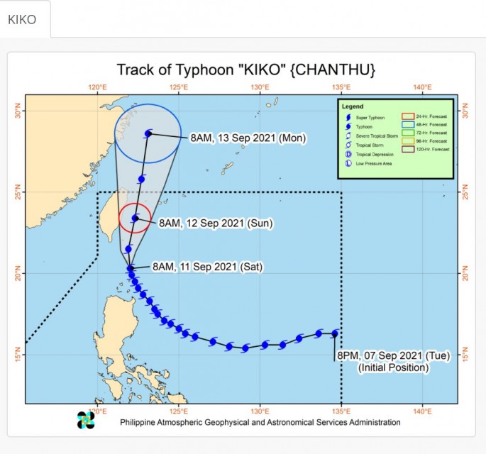
(Eagle News) – Typhoon Kiko (international name Chanthu) made landfall at 8:30 a.m., Saturday, Sept. 11, over Ivana, Batanes, pummeling the province with maximum sustained winds of 205 kilometers per hour near the center and gustiness of up to 250 km per hour.
The whole province of Batanes is under tropical cyclone wind signal no. 4, while the northeastern portion of Babuyan Islands is under signal no. 3. The rest of Babuyan Islands is under signal no. 2.
At 8:30 AM today, Typhoon #KikoPH made landfall over Ivana, Batanes. pic.twitter.com/aC2nfFYt53
— PAGASA-DOST (@dost_pagasa) September 11, 2021
More areas are under signal no. 1. These are the following:
The northern portion of mainland Cagayan (Santa Ana, Gonzaga, Lal-Lo, Gattaran, Lasam, Allacapan, Santa Teresita, Buguey, Aparri, Camalaniugan, Ballesteros, Abulug, Pamplona, Sanchez-Mira, Claveria, Santa Praxedes), the northern portion of Apayao (Flora, Pudtol, Luna, Santa Marcela, Calanasan), and the northern portion of Ilocos Norte (Pagudpud, Adams, Dumalneg, Vintar, Bangui, Burgos)
PAGASA said that typhoon Kiko has slightly weakened as it moved over the coastal waters of Itbayat, Batanes.
It is moving northwestward at 15 kilometers per hour.
As of 10 a.m., the center of the eye of typhoon “KIKO” was located over the coastal waters of Itbayat, Batanes.
“In the next 24 hours, typhoon “KIKO” will bring heavy to intense with at times torrential rains over Batanes,” PAGASA said in its 11 a.m. bulletin.
“Moderate to heavy with at times intense rains are also likely over Babuyan Islands, Cagayan, Ilocos Norte, Ilocos Sur, Abra, Apayao, and Kalinga,” it said.
Typhoon “KIKO” will also continue to enhance the Southwest Monsoon, bringing monsoon rains over Metro Manila, the rest of Ilocos Region, and the western sections of Central Luzon and Southern Luzon in the next 24 hours.
The typhoon is forecast to exit the Philippine Area of Responsibility tomorrow evening or on Monday early morning. Outside the PAR, the typhoon will continue to move northward over the East China Sea, according to PAGASA.
(Eagle News Service)


