


Typhoon is far off extreme northern Luzon, and no wind signal hoisted in the country
Trough of typhoon Southwest Monsoon may bring rains over Extreme Northern Luzon, western sections of Central and Southern Luzon
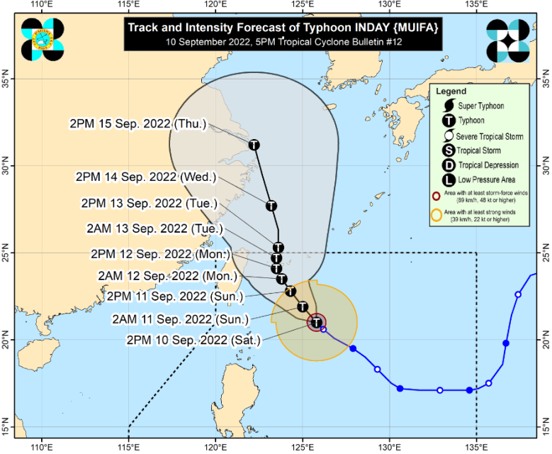
(Eagle News) – Typhoon Inday has intensified further on Saturday, September 10, but no tropical cyclone wind signal is hoisted in the country as the typhoon is still 395 kilometers of Itbayat, Batanes — in the extreme northern Luzon region.
According to PAGASA, the country’s weather bureau, typhoon Inday (international name Muifa) “remains less likely to directly bring heavy rains in the country throughout the forecast period.”
“However, its trough and the Southwest Monsoon may bring rains over Extreme Northern Luzon and the western sections of Central and Southern Luzon,” PAGASA said in its 5 pm bulletin.
Because of the typhoon, a gale warning is in effect for the northern seaboards of Northern Luzon.
-Hoisting of wind signals, less likely at this time-
“The latest forecast scenario for INDAY shows that while the hoisting of Tropical Cyclone Wind Signals remains less likely at this time, further westward shift in the track forecast and/or expansion in the extent of tropical cyclone winds may result in the hoisting of wind signals over portions of Extreme Northern Luzon,” the Philippine weather bureau said.
As of PAGASA’s 5 p.m. bulletin, the center of the eye of typhoon Inday was estimated based on all available data at 395 km East of Itbayat, Batanes (21.3 °N, 125.6 °E )
It is moving Northwestward at 10 kilometers per hour, and has maximum sustained winds of 130 km/h near the center and gustiness of up to 160 km/h.
The typhoon is forecast to decelerate northwestward over the Philippine Sea Saturday, Sept. 10, through Monday “as it tracks towards the sea east of Taiwan before turning slowly north northwestward to northward on Monday afternoon (Sept. 12).
It is expected to further intensify until Sunday or Monday as it tracks northwestward over the Philippine Sea.
“However, the slightly cooler waters east of Taiwan and the forecast slow-down period over this sea area may result in a weakening trend beginning on Tuesday,” PAGASA said.
-Typhoon to exit PHL by Tuesday or Wednesday-
Between Monday afternoon (Sept. 12) and Tuesday morning (Sept. 13), typhoon Inday may pass close to Miyako or Yaeyama Islands in Japan on the forecast track.
It is forecast to exit the Philippine Area of Responsibility (PAR) by Tuesday afternoon or Wednesday early morning.
“Outside the PAR, INDAY will begin to accelerate generally north northwestward while moving over the East China Sea,” PAGASA’s weather advisory said.
(Eagle News Service)


