


But Southwest Monsoon enhanced by “Henry” will continue to bring rains over parts of Luzon, including NCR today
(Eagle News) – Typhoon “Henry” has left the Philippine Area of Responsibility (PAR) but will continue to enhance the Southwest monsoon bringing rains in most areas of Luzon, PAGASA said on Sunday morning, September 4.
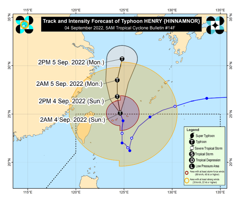
As of the weather bureau’s 5 a.m. bulletin, the eye of the center of Typhoon “Henry” was estimated based on all available data at 590 km North Northeast of Itbayat, Batanes (OUTSIDE PAR) (25.4 °N, 124.7 °E ) and over the East China Sea.
It is moving North Northwestward at 15 kilometers per hour with maximum sustained winds of 150 km/h near the center and gustiness of up to 185 km/h.
-Wind signals lifted-
There are no more wind signals in the country.
However, PAGASA said that the Southwest Monsoon enhanced by this typhoon would “bring monsoon rains over the northern and western section of Northern Luzon and the western section of Northern and Central Luzon” until 5 a.m. Monday, Sept. 5.
The combined effect of the Southwest Monsoon and typhoon “Henry” will bring moderate to heavy with at times intense rains over Ilocos Region, Abra, Benguet, Zambales, and Bataan.
Meanwhile, light to moderate with at times heavy rains will prevail over Metro Manila, the rest of Cordillera Administrative Region, Calabarzon, Batanes, Cagayan, Nueva Vizcaya, Tarlac, Nueva Ecija, Pampanga, Bulacan, and Occidental Mindoro.
Under these conditions, scattered flooding and rain-induced landslides are likely, especially in areas that are highly or very highly susceptible to these hazards as identified in hazard maps and in areas with significant antecedent rainfall. The public and disaster risk reduction and management offices concerned are advised to take all necessary measures to protect life and property, said PAGASA’s advisory.
Despite the lifting of Tropical Cyclone Wind Signals, PAGASA also said that the” enhanced Southwest Monsoon, its convergence with the typhoon circulation, and the channeling of winds within the Luzon Strait will continue bringing strong winds (strong breeze to near gale strength) with gusts reaching gale-force strength at times over Batanes and Babuyan Islands today (Sunday, Sept. 4)”
A Gale Warning remains in effect for the northern and eastern seaboards of Northern Luzon although the typhoon has already left the country.
PAGASA said that “typhoon ‘Henry’ will continue moving generally northward or north northwestward over the East China Sea and will track towards South Korea, where it is likely to make landfall on Tuesday”
“Prior to next landfall, HENRY is forecast to re-intensify but is less likely to return to super typhoon category,” the weather bureau added.
(Eagle News Service)


