


PAGASA’s forecast scenario says signal no. 2 only the highest wind signal that typhoon will reach in PHL if it maintains its northwestward track
(Eagle News) — Typhoon “Bising” (international name Surigae) maintained its strength and is expected to bring heavy to intense rains over Eastern Visayas and Bicol region, but is not expected to make landfall as its forecast track shows it would veer away from the Luzon landmass, according to PAGASA.
But “the possibility of a close approach scenario is not ruled out,” it said.
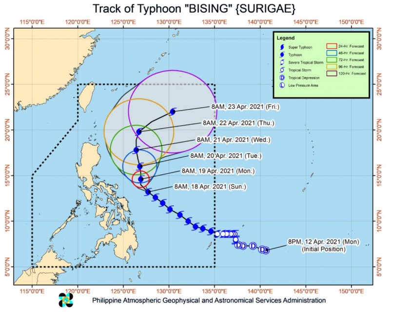
As of 10 a.m. today, Sunday, the center of the eye of Typhoon “BISING” was located at 375 km East of Juban, Sorsogon or 345 km East of Virac, Catanduanes, moving Northwestward at 20 kilometers per hour, with maximum sustained winds of 215 km/h near the center and gustiness of up to 265 km/h
“Bising” is still over the Philippine Sea east of Sorsogon. PAGASA said that by tomorrow, moderate to heavy with at times intense rains will be experienced over Bicol Region and Northern Samar.
The typhoon will “continue to move northwestward over the Philippine Sea east of Bicol Region today and is likely to slow down considerably and begin turning more northward tonight or tomorrow early morning.”
“The typhoon will then continue moving northward until Tuesday (20 April) morning before turning north northwestward while over the Philippine Sea east of Cagayan Valley. By Wednesday evening, the typhoon is forecast to turn northeastward or east northeastward away from the landmass of Luzon,” it said.
-Close approach scenario not ruled out-
“Considering the uncertainty in the track forecast of the typhoon, a westward shift in the current forecast track may result in potentially significant impacts over the eastern portions of Southern Luzon and Visayas. The possibility of a close approach scenario is not ruled out,” it said.
PAGASA said that Bising is also “forecast to maintain its strength today before gradually weakening throughout the remainder of the forecast period.”
However, according to PAGASA’s forecast scenario, only tropical cylone wind signal no. 2 could be the highest signal that Bising could reach. Still, things could change if the typhoon would have a further eastward or westward shift.
“Based on the current forecast scenario, TCWS #2 remains the highest level of wind signal that will be hoisted due to this typhoon. However, in the event of a further eastward or westward shift in the current track forecast, highest level of wind signal that will be hoisted for this typhoon may be lower or higher than the current scenario suggests,” PAGASA said in its 11 a.m. bulletin.
-Areas under tropical cyclone wind signal-
Signal no. 2 is still raised over Catanduanes in Luzon, and Northern Samar, Eastern Samar, and Samar in Visayas where winds from 61 km/hr t0 120 kph would be felt, while signal no. 1 is hoisted in the following areas:
Luzon: The eastern portion of Camarines Norte (San Lorenzo Ruiz, San Vicente, Vinzons, Talisay, Daet, Mercedes, Basud), Camarines Sur, Albay, Sorsogon, and Masbate including Burias and Ticao Islands
Visayas: Biliran, Leyte, Southern Leyte, and the northern portion of Cebu (Tabogon, Borbon, San Remigio, Bogo City, Medellin, Daanbantayan) including Bantayan and Camotes Islands
Mindanao: Dinagat Islands, Siargao Islands, and Bucas Grande Islands
PAGASA said that “tropical cyclone winds of at least strong breeze to near gale in strength extend outward up to 440 km from the center of the typhoon. Destructive typhoon-force winds extend outward up to 110 km from the center of the typhoon.
-Sea travel still risky-
In the next 24 hours, under the influence of Typhoon “BISING” and an enhanced northeasterly wind flow, the following sea conditions will be experienced over the coastal waters of the country:
Very rough to very high seas will be experienced over the northern and eastern seaboard of Eastern Visayas (4.0 to 12.0 m), rough to very high seas over the eastern seaboard of Luzon (2.5 to 12.0 m), and rough to very rough seas over the eastern seaboard of Caraga (3.0 to 5.0 m). Sea travel is risky for all types of seacrafts over these waters.
Rough to very rough seas over the northern and western seaboards of Northern Luzon (2.5 to 5.0 m) and rough seas over the eastern seaboard of Davao Region (2.5 to 3.5 m). Sea travel is risky for small seacrafts over these waters. Mariners without the proper experience should immediately seek safe harbor.
Moderate to rough seas over the western seaboard of Central Luzon and the remaining seaboards of localities where wind signals are in affect (1.5 m to 3.0 m). Mariners of small seacrafts are advised not to venture out over these waters. Inexperienced mariners of these vessels should avoid navigating in these conditions.
(Eagle News Service)


