


Heavy rains forecast starting Sunday, April 18
(Eagle News) — Catanduanes in Luzon, and Samar, Eastern Samar and Northern Samar in Visayas were placed under Tropical Cyclone Wind Signal No. 2 on Saturday at 5 p.m., as typhoon “Bising” (international name Surigae) slighly accelerated while moving west northwestward over the Philippine Sea.
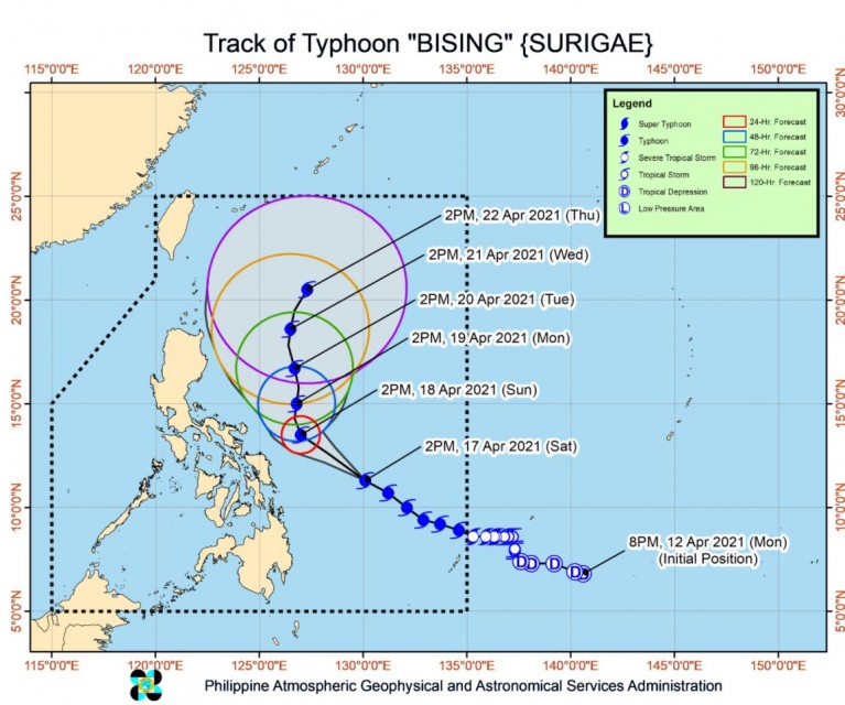
At 4 p.m. Saturday, April 17, the eye of typhoon Bising was at 460 kilometers east of Guian, Eastern Samar, moving west northwestward at 25 kilometers per hour. Bising has maximum sustained winds of 195 km/h near the center and gustiness of up to 240 km/h, the country’s weather bureau, PAGASA, said in its 5 p.m. bulletin.
Tomorrow, Sunday, the typhoon’s ringbands “will bring moderate to heavy with at times intense rains over Eastern Visayas, Bicol Region, and the southern portion of Quezon.” By Monday, April 19, moderate to heavy with at times intense rains will be felt over Northern Samar, Bicol Region, and the southern portion of Quezon. Flashfloods can occur, including rain-induced landslides.
-Areas under Signal no. 1
Signal no. 1 is hoisted over these areas all over the country as “Bising” moved nearer:
Luzon: Sorsogon, Albay, the eastern portion of Camarines Sur (Calabanga, Naga City, Pili, Bula, Bombon, Magarao, Canaman, Gainza, Camaligan, Milaor, Minalabac, Tinambac, Siruma, Lagonoy, Goa, Tigaon, Ocampo, Baao, Iriga City, Nabua, Balatan, Bato, Buhi, Sagnay, San Jose, Garchitorena, Presentacion, Caramoan, San Fernando), and the eastern portion of Masbate (Baleno, Masbate City, Mobo, Uson, Dimasalang, Palanas, Cataingan, Pio V. Corpuz) including Ticao Island
Visayas: Biliran, Leyte, Southern Leyte, and Camotes Islands
Mindanao: Dinagat Islands, Surigao del Norte (including Siargao and Bucas Grande Islands), and Surigao del Sur
-Peak intensity by Sunday-
“BISING” is forecast to further intensify and reach its peak intensity (up to 205 km/h) tomorrow, Sunday, April 18.
“In the next 24 hours, rough to high seas (3.0 to 10.0 m) will be experienced over the eastern seaboards of Luzon and areas where TCWS is in effect while rough to very rough seas (2.8 to 4.5 m) over the remaining seaboards of Northern Luzon and the eastern seaboards of Mindanao (that are not under TCWS). Sea travel is risky for all types of seacrafts over these waters, especially those under TCWS,” PAGASA said.
It said that Bising is forecast to move northwestward over the Philippine Sea until Sunday afternoon. “Afterwards, the typhoon will slow down and move generally northward until Tuesday (20 April) afternoon before moving generally northward or north-northwestward over the Philippine Sea east of Northern and Central Luzon.”
“Considering the uncertainty in the track forecast of typhoon “BISING”, a westward shift in the current forecast track may result in potentially significant impacts over the eastern portions of Southern Luzon and Visayas,” it added.
Bising, the second tropical cyclone and the first typhoon to enter the country this year
(Eagle News Service)


