


(Eagle News) — Typhoon “Ambo” has made landfall over Burias Island in Masbate at 3 a.m. Friday morning, the fifth landfall since Thursday, as “Ambo” continued to weaken, according to the country’s weather bureau, PAGASA.
PAGASA said that typhoon “Ambo” is forecast to move towards Ragay Gulf before it is expected to make landfall again over the Bondoc Peninsula in Southern Quezon this morning.
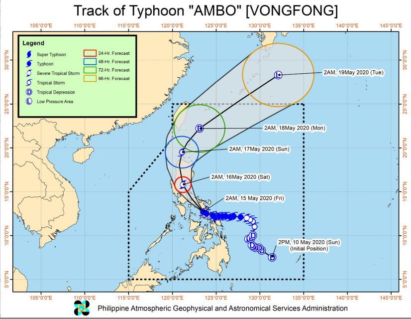
So far, typhoon “Ambo” has already made five landfalls as follows: San Policarpo, Eastern Samar (12:15 PM yesterday); Dalupiri Island, Northern Samar (10:15 PM yesterday); Capul Island, Northern Samar (10:30 PM yesterday); Ticao Island, Masbate (12:00 AM today); and Burias Island, Masbate (3:00 AM today).
PAGASA, in its bulletin issued at 5 a.m. today, said moderate to heavy with at times intense rains are expected over Bicol Region, Quezon, Aurora, and Marinduque.
At 4 a.m. today, the eye of Typhoon “AMBO” was located based on all available data including those from Virac and Daet Doppler Radars at in the vicinity of Claveria, Masbate (Burias Island) (12.9 °N, 123.2 °E )
It is moving Northwest at 15 kilometers per hour, with maximum sustained winds of 125 km/h near the center and gustiness of up to 165 km/h.
-Areas with Tropical Cyclone Wind Signal-
Tropical Cyclone Wind Signal no. 3 is hoisted in the following areas in Luzon:
Sorsogon, Albay, Northern Masbate (Aroroy, Mandaon, Milagros, Baleno, Masbate City, Mobo, Uson) including Ticao and Burias Islands, Camarines Norte, the western portion of Camarines Sur (Del Gallego, Ragay, Lupi, Sipocot, Libmanan, Cabusao, Pasacao, Pamplona, Gainza, Camaligan, Canaman, Magarao, Bombon, Calabanga, Tinambac, Siruma, Goa, Naga City, Milaor, San Fernando, Minalabac, Pili, Ocampo, Tigaon, Sagñay, Buhi, Iriga City, Baao, Bula, Balatan, Nabua, Bato), and the southern portion of Quezon (Pagbilao, Atimonan, Padre Burgos, Agdangan, Plaridel, Unisan, Gumaca, Pitogo, Perez, Alabat, Quezon, Tagkawayan, Calauag, Lopez, Macalelon, General Luna, Catanauan, Buenavista, Guinayangan, Mulanay, San Narciso, San Andres, San Francisco)
These areas may experience winds of 121 km/h up to 170 km/h m in at least 18 hours.
Tropical Cyclone Wind Signal no. 2 is hoisted in these areas in Luzon and the Visayas which will experience winds between 61 km/h up to 120 km/h in at least 24 hours:
Luzon
Nueva Vizcaya, Quirino, Aurora, Nueva Ecija, Tarlac, Pampanga, Bulacan, Metro Manila, Rizal, Laguna, Cavite, Batangas, the rest of Quezon, the rest of Masbate, the rest of Camarines Sur, Catanduanes, and the eastern portion of Romblon (Banton, Corcuera, Calatrava, San Agustin, Romblon, Magdiwang, San Fernando, Cajidiocan)
Visayas
The western portion of Northern Samar (San Vicente, Capul, San Antonio, Allen, Victoria, San Isidro, Biri, Lavezares, Rosario, San Jose)
Meanwhile, these areas are under Tropical Cyclone Wind Signal no. 1:
Luzon
Cagayan including Babuyan Islands, Isabela, Ilocos Norte, Ilocos Sur, La Union, Pangasinan, Apayao, Kalinga, Abra, Mountain Province, Ifugao, Benguet, Zambales, Bataan, Oriental Mindoro, and the rest of Romblon.
Visayas
The rest of Northern Samar, the extreme northern portion of Eastern Samar (Jipapad, Arteche, Maslog), the northern portion of Samar (Calbayog City, Tagapul-an, Almagro, Sto. Niño. Tarangnan, Sta. Margarita, Gandara, Pagsanghan, San Jorge, San Jose de Buan, Matuguinao), Biliran, the extreme northwestern portion of Leyte (Calubian, San Isidro), the extreme northeastern portion of Capiz (Pilar, Panay, Roxas, Ivisan), and the northeastern portion of Iloilo (Carles, Balasan, Estancia, Batad)
“Winds of 30-60 km/h may be expected in at least 36 hours or intermittent rains may be expected within 36 hours,” PAGASA said.
By tomorrow, Thursday, May 16, moderate to heavy with at times intense rains over Cagayan Valley, Apayao, Kalinga, Mountain Province, Ifugao, Aurora, and the northern portion of Nueva Ecija.
“Residents in these areas are advised to take appropriate measures, coordinate with local disaster risk reduction and management offices, and continue monitoring for updates, especially the local rainfall or thunderstorm advisories and heavy rainfall warnings from PAGASA Regional Services Divisions (PRSD). Flooding and rain-induced landslides may occur in highly to very highly susceptible areas during heavy or prolonged rainfall,” it said.
“In the next 24 hours, storm surge height of up to 2.0 meters may be experienced over the coastal areas of Bicol Region, Quezon, and Aurora which may result to potentially life-threatening coastal inundation. Sea travel is risky for all types of seacrafts over the seaboards of areas under TCWS,” PAGASA warned.
-Typhoon Ambo to be outside PAR by Tuesday morning-
Typhoon Ambo is forecast to be in the vicinity of Pantabangan, Nueva Ecija(15.8°N, 121.2°E) by tomorrow morning, Saturday.
By Sunday morning), it is expected to be 45 km Northwest of Calayan, Cagayan(19.5°N, 121.1°E); and by Monday morning, it is forecast to be 225 km North Northeast of Basco, Batanes(22.2°N, 123.1°E)
By Tuesday morning, PAGASA said typhoon Ambo will aready be outside the Philippine Area of Responsibility (PAR) or 1,345 km Northeast of Extreme Northern Luzon.
(Eagle News Service)


