


(Eagle News) – Tropical Depression “Dodong” has “exited” the Philippine Area of Responsibilty” (PAR) as of 9:30 p.m. Wednesday, June 26, according to the country’s weather bureau, PAGASA.
In its 11 p.m. bulletin Wednesday, PAGASA said that “Dodong” is now outside the country.
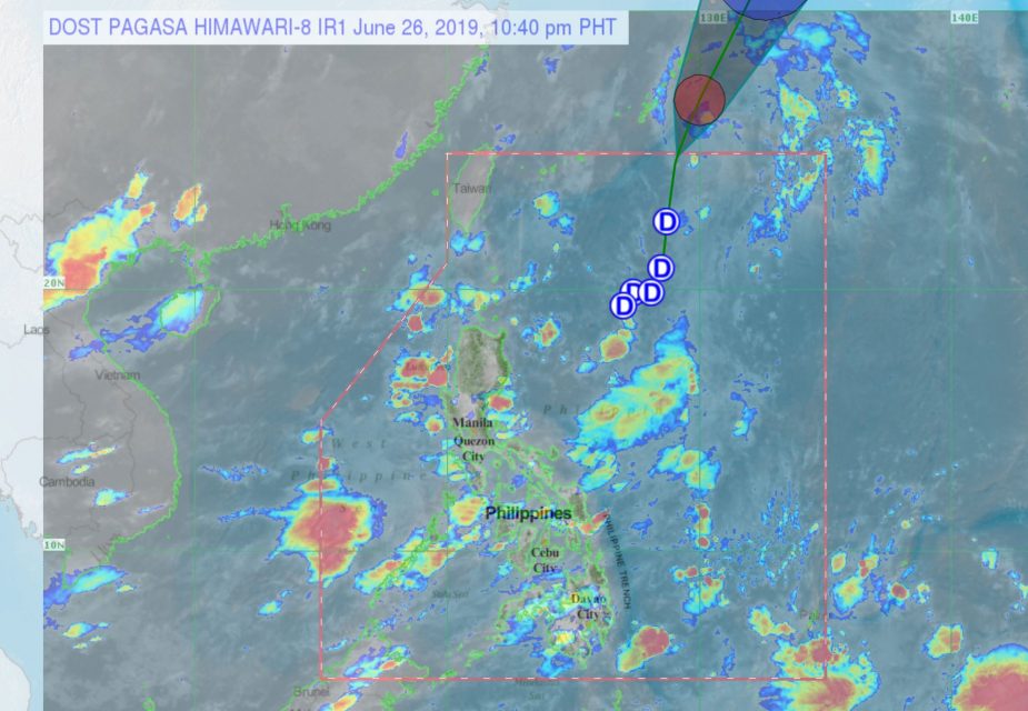
As of 10 p.m. the center of the tropical depression was “estimated based on all available data at 980 km Northeast of Basco, Batanes (OUTSIDE PAR) (25.5 °N, 129.8 °E ),” according to the latest PAGASA update.
It was moving north at 35 kilometers per hour, with maximum sustained winds of 45 kph near the center and gustiness of up to 60 kph.
PAGASA said that even after “Dodong” has left PAR, the Southwest Monsoon or habagat would still “bring scattered rainshowers and thunderstorms over the western section of Luzon and Visayas tonight.”
Tomorrow, Thursday, June 27, “light to moderate (monsoon rains) with occasional heavy rains may prevail over Metro Manila, western portions of Central Luzon (Zambales, Pampanga, Bataan, Bulacan), CALABARZON( Cavite and Batangas), MIMAROPA (Mindoro Provinces and
Northern Palawan including Cuyo and Calamian Islands), and Western Visayas (Antique, Aklan, Capiz, Iloilo and Guimaras),” PAGASA said.
“Residents in these areas, especially those living in areas identified to be at high risk of flooding and landslides, are advised to continue monitoring for updates, take precautionary measures and coordinate with local disaster risk reduction and management offices,” it said.
PAGASA is also monitoring a low pressure area more than 400 kilometers west-northwest of Coron, Palawan. It is also monitoring another low pressure area which is still outside the Philippines.
It said that the LPA was spotted 1,680 kilometers east of Mindanao as of 3 p.m., but is not expected to develop into a tropical depression.
It is expected to enter PAR on Saturday.


