


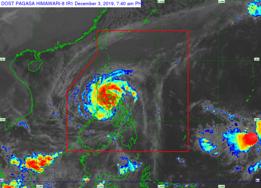
(Eagle News) — Typhoon Kammuri (local name Tisoy) has maintained its strength as its eyewall is “currently bringing violent winds and heavy to intense rainfall over Southern Quezon, Marinduque and Romblon.”
Tisoy is “now just off the coast of the Bondoc Peninsula,” according to PAGASA’s weather bulletin at 8 a.m., Tuesday, Dec. 3.
“The eye is expected to make landfall or pass close to Marinduque-Simara Island-Banton Island area before noon,” the country’s weather bureau, PAGASA, said.
As of 7 a.m. today, the eye of Typhoon “TISOY” was located based on all available data at in the coastal waters of San Francisco, Quezon (13.1°N, 122.6°E).
Tisoy has maximum sustained winds of up to 155 kilometers per hour near the center and gustiness of up to 235 km/h. It is currently moving West at 20 km/h.
Tropical cyclone wind signal number 3 is now over the following areas covering 12 provinces:
Camarines Sur, Albay, Camarines Norte, Masbate including Ticao and Burias Islands, Romblon, southern portion of Quezon (Perez, Alabat, Quezon, Mauban, Sampaloc, Lucban, Tayabas, Pagbilao, Lucena, Sariaya, Candelaria, Dolores, Tiaong, San Antonio, Atimonan, Padre Burgos, Agdangan, Plaridel, Unisan, Pitogo, Gumaca, Lopez, Macalelon, General Luna, Calauag, Catanauan, Guinayangan, Tagkawayan, Buenavista, Mulanay, San Narciso, San Francisco, San Andres), Marinduque, Oriental Mindoro, Occidental Mindoro including Lubang Island, Batangas, Cavite, and Laguna
After passing Catanduanes and Sorsogon Monday night until Tuesday dawn, these two provinces have now been placed under Signal number 2.
These are the complete areas where signal number 2 is hoisted:
Catanduanes, Sorsogon, Metro Manila, Bulacan, Bataan, Tarlac, Pampanga, Nueva Ecija, southern Aurora (Dipaculao, Maria Aurora, Baler, San Luis, Dingalan), Rizal, rest of Quezon including Polillo Islands, Calamian Islands (Coron, Busuanga, Culion, Linapacan), Cuyo Islands (Cuyo, Magsaysay, Agutaya), Zambales, Pangasinan, Northern Samar, Aklan, Capiz, Northern Antique (Caluya, Libertad, Pandan, Sebaste, Culasi, Tibiao), and Northern Iloilo (Carles, Balasan, Estancia, Btad, San Dionisio, Sara, Concepcion, Lemery)
Signal number 1 is hoisted over these provinces:
Southern Isabela (Palanan, Dinapigue, San Mariano, San Guillermo, Benito Soliven, Naguilian, Reina Mercedes, Luna, Aurora, Cabatuan, San Mateo, Cauayan City, Alicia, Angadanan, Ramon, San Isidro, Echague, Cordon, Santiago City, Jones and San Agustin), Mountain Province, Ifugao, Benguet, Nueva Vizcaya, Ilocos Sur, La Union, Quirino, rest of Aurora, northern portion of Palawan (El Nido, Taytay, Araceli, Dumaran), Eastern Samar, Samar, Biliran, northern Negros Oriental (Canlaon, Guihulngan, Vallerhermoso), northern Negros Occidental (Talisay, Calatrava, Silay, Enrique B. Magalona, Victorias, Manapla, Cadiz, Sagay, Escalante, Toboso, Bacolod, Murcia, Salvador Benedicto, San Carlos, Bago, Pulupandan, Valladolid, La Carlota, San Enrique, Pontevedra, La Castellana, Moises Padilla), Northern Cebu (Daanbantayan, Bantayan, Madridejos, Santa Fe, Medellin, Bogo City, San Remigio, Tabogon, Tabuelan, Tuburan, Carmen Borbon, Sogod, Catmon, Asturias, and Camotes Islands), rest of Antique, rest of Iloilo, Guimaras, and Leyte.
“Tropical Cyclone Wind Signals over Bohol, Siquijor, Southern Leyte, and the rest of Cebu, Negros Occidental and Negros Oriental are now lifted,” PAGASA said.
In its advisory, the bureau said that between morning and late afternoon today, there will be frequent to continuous heavy to intense rains over Bicol Region, Romblon, Marinduque, Mindoro Provinces, CALABARZON, Metro Manila, Bataan, Pampanga and Bulacan. Occasional to frequent heavy rains over the rest of Central Luzon.
Intermittent heavy rains are still felt over Samar Provinces, Biliran, Aklan, Antique, Capiz, Iloilo, Guimaras, and the northern portions of Negros Provinces and Cebu.
Between late afternoon today and tomorrow morning, there will be frequent to continuous heavy (with isolated intense) rains over Mindoro Provinces, Metro Manila, Central Luzon, Rizal, and Northern Quezon including Polillo Islands. Occasional heavy rains over Cagayan Valley, Cordillera Administrative Region, Marinduque, Romblon and the rest of CALABARZON. Intermittent heavy rains over Bicol Region and Calamian Islands, PAGASA said.
“Residents in the aforementioned areas, especially those living in areas identified to be highly or very highly susceptible to flooding and rain-induced landslides, are advised to take appropriate actions, coordinate with local disaster risk reduction and management offices, and continue monitoring for updates, especially the Thunderstorm or Rainfall Advisories and Heavy Rainfall Warnings to be issued by PAGASA Regional Services Divisions,” PAGASA said in its advisory.
“Sea travel is risky, especially for small seacrafts, over the seaboards of areas under TCWS, the seaboards of Northern Luzon, the western seaboard of Palawan, and the northern and eastern seaboards of Mindanao due to rough sea conditions,” PAGASA said.
“Gusty conditions may also be experienced in areas in Northern Luzon that are not under any TCWS (especially in the coastal and mountainous zones) due to the Northeast Monsoon,” it added.


