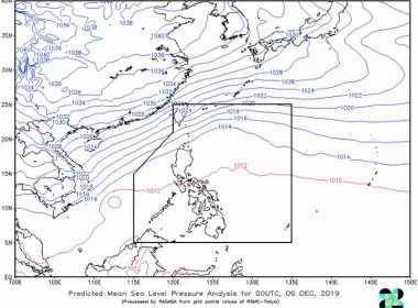
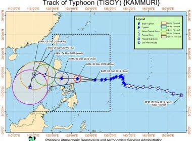
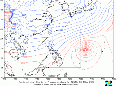
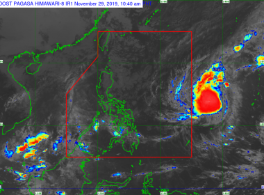
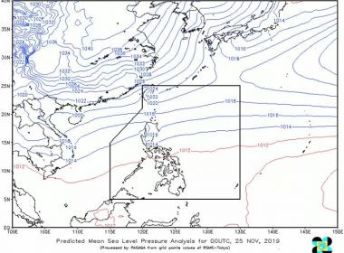
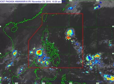
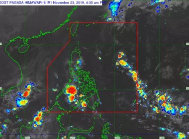
(Eagle News)–Rains are expected in parts of the country as the tail-end of a cold front affects the eastern section of Northern Luzon and the northeast monsoon. The Philippine Atmospheric Geophysical and Astronomical Services Administration said Cagayan Valley and Cordillera Administrative Region will have cloudy skies with scattered rainshowers and thunderstorms. Flash floods and landslides due to moderate to heavy rains are possible. Ilocos Region will have cloudy skies with light rains, while Metro Manila […]
Tag: weather update
Rains expected in parts of PHL due to northeast monsoon, tail-end of cold front
(Eagle News)–Rains are expected in parts of the country due to the northeast monsoon and the tail-end of a cold front. The Philippine Atmospheric Geophysical and Astronomical Services Administration said this as “Tisoy” further weakened into a tropical storm, and no longer had any effect on the country. As of 3 a.m., PAGASA said “Tisoy” was estimated 540 km west of Subic, Zambales, packing maximum sustained winds of 65 kph near center and gustiness of […]
Thunderstorm advisory hoisted over parts of Mindanao
(Eagle News)–A thunderstorm advisory has been hoisted over parts of Mindanao. The Philippine Atmospheric Geophysical and Astronomical Services Administration said moderate to heavy rainshowers with lightning and strong winds due to thunderstorms are expected over Davao City, Lanao del Norte, Lanao del Sur, Misamis Occidental and Zamboanga del Sur within one to two hours. These conditions are being experienced in Banaybanay, Davao Oriental; Pantukan, Mabini, Maco in Davao de Oro; SamalIs, Panabo, Tagum in Davao […]
All cyclone signals now lifted; “Tisoy” forecast to exit PAR between tonight, tomorrow morning
(Eagle News) — All cyclone signals are now lifted as Severe Tropical Storm “Tisoy” slightly weakened and moved over the West Philippine Sea. The Philippine Atmospheric Geophysical and Astronomical Services said as of 10 a.m., the center of “Tisoy” was estimated 290 km west southwest of Subic, Zambales, packing maximum sustained winds of up to 95 kph near the center and gustiness of up to 115 kph. “Tisoy” is moving west northwest at 15 kph, […]
Signal No. 2 now hoisted over Catanduanes, two other areas
(Eagle News)–Signal No. 2 is now hoisted over three areas as Typhoon “Tisoy” moves westward. The Philippine Atmospheric Geophysical and Astronomical Services Administration said Catanduanes, Northern Samar and Eastern Samar are under the storm signal. Signal No. 1, on the other hand, is hoisted over Quezon including Polillo Islands, Camarines Norte, Camarines Sur, Albay, Sorsogon, Masbate including Burias and Ticao Island, Marinduque, and Romblon, Aklan, Capiz, northern Iloilo (Ajuy, Anilao, Balasan, Banate, Barotac Viejo, Batad, […]
Cloudy skies, rains forecast in parts of PHL today
(Eagle News)–Cloudy skies with rains are expected in parts of the country today. The Philippine Atmospheric Geophysical and Astronomical Services Administration said cloudy skies with scattered rains will be felt in the Cordillera Administrative Region, Cagayan Valley, and the provinces of Aurora and Quezon, as the northeast monsoon affects Northern Luzon. Palawan, Visayas and Mindanao, on the other hand, will have partly cloudy to cloudy skies with isolated rainshowers due to localized thunderstorms. Flash floods […]
Cloudy skies, rains forecast in parts of N. Luzon due to northeast monsoon
(Eagle News) — Cloudy skies with scattered rainshowers are expected over parts of Northern Luzon as the northeast monsoon affects the island group. The Philippine Atmospheric Geophysical and Astronomical Services Administration said these conditions will be felt in the provinces of Batanes, Cagayan, Isabela, Nueva Vizcaya, Quirino, Apayao, Kalinga, Abra, Mt. Province, Ifugao, Benguet and Aurora. PAGASA said partly cloudy to cloudy skies with isolated rains, on the other hand, will prevail over Ilocos Norte, […]
PAGASA: Typhoon “Kammuri” almost stationary but is still forecast to enter PAR over the weekend
(Eagle News) — Typhoon “Kammuri” has remained almost stationary in the last six hours but is still forecast to enter the Philippine Area of Responsibility over the weekend. The Philippine Atmospheric Geophysical and Astronomical Services Administration said as of 3 p.m., “Kammuri” was located 1455 kilometers east of Southern Luzon, packing maximum sustained winds of 140 kilometers per hour and gustiness of up to 170 kph. PAGASA said “Kammuri” is forecast to enter PAR between […]
Rains forecast in parts of N. Luzon
(Eagle News) — A rainfall advisory has been hoisted over parts of Northern Luzon. The Philippine Atmospheric Geophysical and Astronomical Services Administration said moderate to heavy rains are expected over portions of Dilasag and Casiguran and Aurora within an hour. Meanwhile, moderate to heavy rains are being experienced over Palanan,San Mariano, Dinapigue, San Agustin in Isabela; and Maddela in Quirino. PAGASA said these may persist for one to two hours and may effect nearby areas. […]
Cloudy skies, light rains expected in parts of PHL today
(Eagle News)–Cloudy skies with scattered rainshowers and thunderstorms are expected in parts of the country today. The Philippine Atmospheric Geophysical and Astronomical Services Administration said Bicol Region, Aurora and Quezon will have cloudy skies with scattered rainshowers and thunderstorms due to the easterlies. Flash floods or landslides during severe thunderstorms are possible. Ilocos Region, Cordillera Administrative Region, and Cagayan Valley will have partly cloudy to cloudy skies with isolated light rains as the northeast monsoon […]
“Sarah” weakens into LPA, is now outside PAR
(Eagle News)–“Sarah” has weakened into a low pressure area and is now outside the Philippine Area of Responsibility. The Philippine Atmospheric Geophysical and Astronomical Services Administration said “Sarah” exited PAR at 6 a.m. today and weakened into a LPA at 8 a.m. As of 10 a.m., PAGASA said “Sarah” was spotted 635 km north northeast of Basco, Batanes. Gale warnings across all seaboards of the country remain terminated due to the weakening of the northeast […]
“Sarah” weakens into tropical depression
(Eagle News)–“Sarah” has weakened into a tropical depression, and is at the northern boundary of the Philippine Area of Responsibility. The Philippine Atmospheric Geophysical and Astronomical Services Administration said “Sarah,” which is forecast to exit PAR in several hours, may further weaken into a low pressure area before it does this. As of 4 a.m., “Sarah” is located 700 kilometers northeast of Basco, Batanes, packing maximum sustained winds of 55 kilometers per hour near the […]


