


(Eagle News) – Super Typhoon “Henry” (international name Hinnamnor) slightly intensified while moving south southwestward northeast of Batanes with maximum sustained winds of 195 kilometers per hour and gusts of up to 240 kilometers per hour.
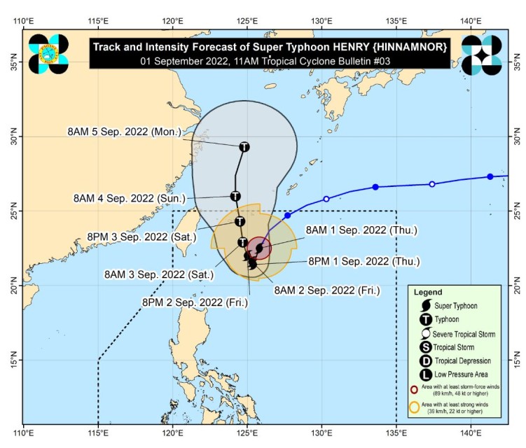
The center of the eye of Super Typhoon Henry was estimated at 430 kilometers east northeast of Itbayat, Batanes as of the 11 a.m. bulletin, of PAGASA, the country’s weather bureau, on Thursday, September 1. It entered the country on Wednesday night, August 31.
PAGASA said that “Henry” is forecast to “enhance the Southwest Monsoon which may bring rains over the western section of Luzon beginning tomorrow” September 2. It is moving South Southwestward at 25 km/h.
As of 11 a.m., “Gardo” the other weather disturbance northeast of Itbayat, Batanes, further weakened into a “remnant” low pressure area (LPA) and was located 760 km East Northeast of Itbayat, Batanes.
-Super typhoon “Henry” to fully assimilate LPA “Gardo”-
PAGASA said “Gardo” weakened into a remnant low at 8 a.m. on Thursday, Sept. 1 and its circulation would likely be “fully assimilated within the circulation of Super Typhoon HENRY in the next 12 hours.”
The weakened “Gardo” on its own would not be able to affect any part of the country.
But super typhoon Henry (Hinnamnor) because of its strength would cause “light to moderate with at times heavy rains” over Batanes Thursday late afternoon through evening.
PAGASA said that “Tropical Cyclone Wind Signals (TCWS) may be hoisted for localities in Extreme Northern Luzon by Thursday at the earliest in anticipation of potential strong breeze to near gale conditions.”
“The potential for hoisting a Wind Signal No. 2 is also not ruled out,” it said.
A Gale Warning is in effect for the northern and eastern seaboards of Northern Luzon. In the next 24 hours, HENRY may bring moderate to rough seas over the eastern seaboard of Isabela (1.2 to 4.0 m).
“These conditions may be risky for those using small seacrafts. Mariners are advised to take precautionary measures when venturing out to sea and, if possible, avoid navigating in these conditions,” PAGASA said.
By Friday, Sept. 2, moderate to heavy rains are likely over Batanes and Babuyan Islands.
Early morning Saturday, Sept. 3, through the afternoon, moderate to heavy rains are possible over Batanes, with light to moderate with at times heavy rains over the Babuyan Islands.
“Under these conditions, isolated to scattered flooding (including flash floods) and rain-induced landslides are possible especially in areas that are highly or very highly susceptible to these hazard as identified in hazard maps, and in localities with significant antecedent rainfall,” PAGASA said.
Super Typhoon HENRY is forecast to continue moving generally south southwestward on Thursday (Sept. 1) through early morning Friday (Sept. 2) while decelerating.
By Thursday night (Sept. 1) or Friday early morning (Sept. 2), the tropical cyclone may become almost stationary.
By Friday afternoon, the super typhoon “may begin tracking slowly northwestward before eventually accelerating northward by Saturday.”
-“Henry” to exit PHL by Saturday night or Sunday morning-
“On the forecast track, HENRY may exit the Philippine Area of Responsibility on Saturday evening or Sunday morning,” PAGASA said.
“This super typhoon is forecast to further intensify during the remaining time window before it enters its slowdown or quasi-stationary phase, when it is likely to begin weakening. Once it begins accelerating northward during the weekend, a slight re-intensification may still occur,” it explained.
(Eagle News Service)


