


(Eagle News) — Tropical Storm “Auring” (international name Dujuan) slightly weakened as it began to move northwestward on Saturday afternoon, Feb. 20, but maintained strength afterwards as it remained almost stationary near Surigao del Sur around 10 p.m, according to the country’s weather bureau, PAGASA.
In its 11 p.m. bulletin, PAGASA said that there is an “increasing likelihood that ‘AURING’ will weaken into a tropical depression before it makes landfall.”
This is “due to persistent vertical wind shear and dry air intrusion associated with the surge of the Northeast Monsoon.”
“However, the possibility that the storm will maintain its strength until landfall is not yet ruled out. Post-landfall, ‘AURING’ is expected to weaken considerably due to significant terrain interaction and the increasing wind shear, leading to deterioration into a remnant low within 48 hours, possibly sooner,” PAGASA said in its 11 p.m. advisory.
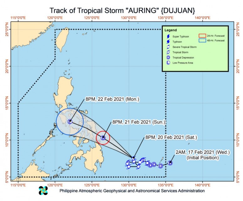
As of 10 p.m. Saturday, Feb. 20, the center of Tropical Storm “AURING” was estimated based on all available data at 480 km East Southeast of Hinatuan, Surigao del Sur (07.5 °N, 130.6 °E ). It was also “moving almost stationary” with mMaximum sustained winds of 65 km/h near the center and gustiness of up to 80 km/h
The storm is “forecast to continue moving generally northwestward in the next 48 hours, with periods of erratic movement prior to making landfall.”
“On the forecast track, ‘AURING’ will likely make landfall over the Dinagat Islands-Eastern Samar (southern portion including Homonhon Island)-Leyte area between tomorrow evening and Monday early morning,” PAGASA said.
At 4 p.m. Saturday, the center of Tropical Storm “AURING” was estimated based on all available data at 440 km East Southeast of Hinatuan, Surigao del Sur (07.3 °N, 130.2 °E ). At that time, it was moving Northwestward at 15 kilometers per hour.
-Areas under Signal no. 1-
The areas placed under signal number 1 included regions with reported high cases of COVID-19 in the Visayas and Mindanao.
As of the 11 p.m. weather bulletin on Saturday, Feb. 20, these areas are under Tropical Cyclone Wind Signal number 1:
Luzon:
The southeastern portion of Masbate (Cataingan, Cawayan, Dimasalang, Esperanza, Palanas, Pio V. Corpuz, Placer)
Visayas:
Northern Samar, Eastern Samar, Samar, Biliran, Leyte, Southern Leyte, Cebu, Negros Oriental, Bohol, Siquijor, and the northern portion of Negros Occidental (Bacolod City, Bago City, Cadiz City, Calatrava, Enrique B. Magalona, Escalante City, Manapla, Murcia, Sagay City, Salvador Benedicto, San Carlos City, Silay City, Talisay City, Toboso, Victorias City)
Mindanao:
Dinagat Islands, Surigao del Norte, Surigao del Sur, Agusan del Norte, Agusan del Sur, Davao Oriental, Davao de Oro, Davao del Norte, Davao City, Camiguin, Misamis Oriental, and Bukidnon.
-Moderate to heavy rains-
On Sunday, Feb. 21, PAGASA forecasts moderate to heavy rains over Eastern Samar, Dinagat Islands, and Surigao del Norte. Light to moderate with at times heavy rains over Bicol Region, MIMAROPA, Northern Mindanao, Zamboanga Peninsula, Quezon, and the rest of Visayas and Caraga.
On Monday, Feb. 22, it forecasts light to moderate with at times heavy rains over Bicol Region, MIMAROPA, Western Visayas, Northern Samar, Samar, Eastern Samar, Quezon, Aurora, Isabela, and Cagayan.
“Under these conditions, isolated to scattered flooding (including flash floods) and rain-induced landslides are likely during heavy or prolonged rainfall especially in areas that are highly or very highly susceptible to these hazards as identified in hazard maps. Adjacent or nearby areas may also experience flooding in the absence of such rainfall occurrence due to surface runoff or swelling of river channels,” the PAGASA bulletin said.
PAGASA said that in the next 24 hours, “the combined effects of the surge of the Northeast Monsoon and Tropical Storm ‘AURING’ will bring strong breeze to near-gale conditions with occasionally higher gusts over the areas where Tropical Cyclone Wind Signals are in effect.
This will also be the case for for “CALABARZON, MIMAROPA, Aurora, and the rest of Visayas and Bicol Region.
PAGASA said that in the next 24 hours, rough to high seas (2.6 to 6.0 m) will be experienced over the seaboards of areas under Tropical Cyclone Wind Signal. Rough to very rough seas (2.6 to 4.5 m) will also prevail over the eastern seaboard of Luzon. Rough seas (2.5 to 4.0 m) will prevail over the southern seaboard of Luzon (including the eastern seaboard of Palawan), the remaining seaboards of Visayas, and the northern, eastern, and western seaboards of Mindanao that are not under any TCWS. Sea travel is risky for all types of sea vessels over these waters.
Moderate to rough seas (1.2 to 3.0 m) will be experienced over the remaining seaboards of the country. Mariners of small seacrafts are advised to take precautionary measures when venturing out to sea. Inexperienced mariners should avoid navigating in these conditions, PAGASA said.
(Eagle News Service)


