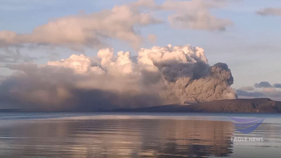
Video taken early morning of Jan. 14, 2020, before 7 a.m., as Taal Volcano exhibited “continuous eruption”. Phivolcs, in its 8 a.m. bulletin issued on Jan. 14, 2020 said that “for the past 24 hours, Taal Volcano’s activity has been characterized by continuous eruption of the Main Crater due to magmatic and hydrovolcanic activity.” (Eagle News Service)
(Eagle News) – New vent craters have been formed inside Taal Volcano’s main crater and on the north flank of the volcano based on newly acquired satellite images, according to the Philippine Institute of Volcanology and Seismology (PHIVOLCS).
In its latest bulletin issued at 5 p.m. Wednesday, PHIVOLCS also noted that Taal’s “continuous magmatic and hydrovolcanic activity” has generated “700-meter tall dark gray steam-laden plumes that drifted to the general southwest.”
PHIVOLCS said that the new images it had acquired also showed that the Main Crater Lake “has been drained.”
“Newly acquired satellite images would show that the Main Crater Lake (MCL) has been drained and new vent craters have been formed inside the Main Crater and on the north flank of the volcano,” PHIVOLCS said in its 5 p.m. bulletin.
It also noted fissures in Lemery town in Batangas, particularly in the barangay of Sambal Ibaba.
These were in addition to the previously identified fissures in Lemery, particularly in barangays Sinisian, Mahabang Dahilig, Dayapan, Palanas, Sanggalang, Poblacion, Mataas na Bayan; Agoncillo, particularly in barangays Pansipit, Bilibinwang), Talisay (Poblacion 1, Poblacion 2, Poblacion 3, Poblacion 5; and in bgy. Poblacion in San Nicolas.
“Drying up of portions of Pansipit River has also been observed,” PHIVOLCS said.
The Philippine Seismic Network also plotted 520 volcanic earthquakes since 1 p.m. of Sunday, Jan. 12, with 169 of these felt with intensities ranging from intensities 1 to 6.
Since 5 a.m. to 4 p.m. today, Wednesday, Jan. 15, there were 53 volcanic earthquakes plotted and 12 of which were felt with intensities ranging from Intensity 1 to 3.
“Such intense seismic activity probably signifies continuous magmatic intrusion beneath the Taal edifice, which may lead to further eruptive activity,” Phivolcs said.
Taal Volcano is still under alert level 4 which means that “hazardous explosive eruption is possible within hours to days.”
PHIVOLCS again stressed the need for the “total evacuation of Taal Volcano Island and high-risk areas as identified in the hazard maps within the 14-km radius from Taal Main Crater.”
It also advised the total evacuation of those living along the Pansipit River Valley where fissuring has been observed.
As in the previous PHIVOLCS bulletin, “residents around Taal Volcano are advised to guard against the effects of heavy and prolonged ashfall.”
“Civil aviation authorities must advise pilots to avoid the airspace around Taal Volcano as airborne ash and ballistic fragments from the eruption column pose hazards to aircraft.”


