

by Amélie BOTTOLLIER-DEPOIS
Agence France Presse
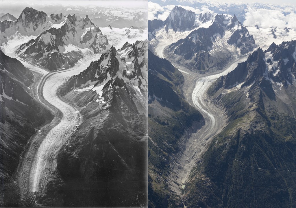
PARIS, France (AFP) — In 1919 a pioneering aviator took iconic photos of the Mont Blanc glaciers. A century later, a team of experts has recreated the images to highlight the drastic ice melt caused by rising temperatures.
Despite an overwhelming body of scientific evidence tracking humanity’s contribution to climate change, it is often difficult to grasp the enormity of a phenomenon that unfolds so gradually.
Numerous studies have been made of the vanishing glaciers surrounding Europe’s tallest mountain, but the University of Dundee experts decided to go one better in an attempt to demonstrate in stark visual terms the damage wrought by global warming.
They painstakingly set about recreating three iconic images captured 100 years ago by Walter Mittelholzer, a Swiss pilot and photographer, of the Sea of Ice, Bossons and Argentiere glaciers.
Using the latest geolocation and 3D visualisation techniques, they were able to pinpoint the precise patch of sky from which Mittelholzer snapped the photos for maximum impact.
“One of the driving forces behind this work is to try to make the narrative the scientists understand very well understood by people who don’t have this specialist knowledge and can recognise these undeniable changes,” the University of Dundee’s Kieran Dexter told AFP.
The result is a startling contrast between the sprawling, glistening glaciers of the early 20th century and swathes of dull, dried earth today.
The levels of melt on the Sea of Ice glacier, France’s largest, are particularly noticeable.
“It’s jaw-dropping to see those changes, but it was not a surprise for us,” Dexter said.
– ‘Breathtaking and heartbreaking’ –
“We knew the kind of changes we were expected to see but from that height you can get the scale of what is happening. It’s still breathtaking and heartbreaking.”
The UN’s Intergovernmental Panel on Climate Change last month released a landmark assessment of Earth’s frozen spaces, known as the cryosphere.
It found that under current rates of warming the glaciers of Europe and Scandinavia could melt by as much as 80 percent by the end of the century.
As well as destabilising the mountainsides to which they have clung for millennia, vanishing glaciers are predicted to have a severe impact on food production — reliant on seasonal meltwater — and on tourism.
Between 1970 and 2015 the Argentiere glacier, northeast of the Sea of Ice, lost 20 percent of its surface.
The Sea of Ice and the Bossons glaciers lost 10 and seven percent respectively, according to Antoine Rabatel, a glaciologist at the Institute of Geosciences and Environment in Grenoble, France.
For him, the photography project serves as a kind of public awareness tool.
“They let you really visualise things, and that’s so important for the wider public as not everyone can go and see what’s happening on the ground,” he said.
The team from the University of Dundee say they plan a similar visualisation project for glaciers in Iceland.
© Agence France-Presse


