


(Eagle News) – Disaster and weather officials warned the public of typhoon Ompong’s strong winds and rains that will affect mostly Northern Luzon, including storm surges that will endanger coastal areas.
In a press briefing, officials of the country’s weather bureau, PAGASA, said that Ompong has a very wide diameter at 900 kilometers which is why it could continue to feed from the seas it is covering and further gain strength. This diameter is even bigger than supertyphoon Yolanda (Haiyan) of November 2013 which only had a diameter of 600 kilometers.
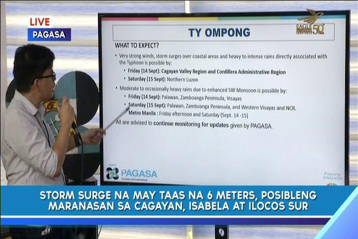
The northern portion of Cagayan province is particularly vulnerable to high storm surges brought by typhoon Ompong, said Dr. Vicente Malano, PAGASA administrator.
-Comparable to supertyphoon Lawin-
PAGASA forecaster Rene Paciente said that Ompong is comparable in strength to supertyphoon Lawin (international name Haima) which is the third most intense tropical cyclone of 2016 in the world. Lawin has maximum winds of 250 kph.
Ompong has maximum sustained winds of 205 kph near the center and gustiness of up to 255 kph.
“Cloudiness na dala ng bagyong ompong, makapal masyado. (Typhoon Ompong’s clouds are so thick),” Paciente said noting that these thick clouds will bring more heavy rains.
By Friday, Sept. 14, PAGASA said that Ompong will bring very strong rains and winds, including storm surges in the Cagayan Valley region and Cordillera Administrative Region.
By Saturday, its strength will be further felt in the entire Northern Luzon.
Dr. Renato Solidum of the Philippine Institute of Volcanology and Seismology (PHIVOLCS) said it is better for those in the coastal areas to be affected by storm surges to evacuate to higher ground as the storm nears.
Ompong slowed down a bit as it continued to move westward over the Philippine Sea at a pace of 20 kilometers per hour.
It has maximum sustained winds of 205 kph near the center and gustiness of up to 255 kph.
At 10:00 a.m. today, Thursday, Sept. 13, the eye of Typhoon “Ompong” was located based on all available data at 725 km East of Virac, Catanduanes.
It is expected to make landfall in northern Cagayan by Saturday morning.
-More areas placed under signal no. 1-
It has placed more areas in Luzon under Signal No. 1 which are the following:
• Batanes
• Cagayan including Babuyan group of Islands
• Apayao
• Abra
• Kalinga
• Mountain Province
• Ifugao
• Isabela
• Benguet
• Quirino
• Nueva Vizcaya
• Aurora
• Nueva Ecija
• Bulacan
• Rizal
• Laguna
• Quezon inc. Polillo Island
• Camarines Norte
• Camarines Sur
• Catanduanes
• Albay
• Sorsogon
• Burias and Ticao island.
In the Visayas region, only Northern Samar is placed under signal number 1.
PAGASA said that Metro Manila will not feel the brunt of typhoon Ompong’s wrath and will just experience light to moderate rains since it is in the “outside periphery” of the 900-kilometer cyclone.
Forecasters said that Ompong might not reach the supertyphoon strength of “Yolanda” but it is still a very strong typhoon that the public should prepare for.


