


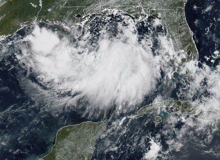
NEW ORLEANS, United States (AFP) — Tropical Storm Barry barreled toward water-logged New Orleans Thursday as the city girded for an ordeal that evoked fearful memories of 2005’s deadly Hurricane Katrina.
The weather system, which has already caused major flooding in the low-lying city, is expected to strengthen and “become a hurricane late Friday or early Saturday,” according to the National Hurricane Center.
With Barry just 90 miles (145 kilometers) from the mouth of the Mississippi River, Governor John Bel Edwards declared a state of emergency and two parishes, as counties are known in Louisiana, called for mandatory evacuations in some locations.
The southern state was bracing for what Edwards said could be “an extreme rain event” that impacts “a huge portion of the state.”
New Orleans Mayor Latoya Cantrell warned her city’s residents to review their emergency plans and supply kits, and to stay updated with the latest forecasts.
The city was under a tropical storm warning, and “we could see impacts as early as Friday morning,” Cantrell said.
“The center of Barry will be near the central or southeastern coast of Louisiana Friday night or Saturday,” the NHC predicted in its 1800 GMT bulletin, forecasting additional strengthening “during the next day or two.”
Despite the dire warnings, downtown New Orleans was bathed in summer sun and a steady breeze ahead of the storm, as tourists lounged in cafes, snapped photographs of the swollen river and bought street art.
“I’m a little nervous,” admitted Lorraine Jones, who was visiting from Charlotte, North Carolina to attend a sorority convention with thousands of fellow members.
“Right now I feel safe, but if push comes to shove, we’ll make a move,” she told AFP.
Residents are keenly aware of the threat, not only from heavy rains and a storm surge from the Gulf, but also the prospect of a swollen Mississippi River — the largest river in North America — breaching the top of levees.
An official with the Army Corps of Engineers said levees south of New Orleans were of concern, but there appeared to be little risk for the city itself, according to CBS News.
On Wednesday, officials said the 118 pumps spread throughout the city were operating at “optimum capacity.”
In 2005, Katrina — the costliest and deadliest hurricane in US history — submerged some 80 percent of New Orleans as its flood defenses gave way.
Best remembered for the devastation wreaked on the city known as The Big Easy, Katrina also pounded other parts of Louisiana as well as Mississippi and Alabama, leading to some 1,800 deaths and inflicting more than $150 billion in damage.
Potential first
If the storm becomes a hurricane as anticipated, it would be the first of the Atlantic season, which runs from June through November.
Crews from the state’s transportation department erected barricades in New Orleans and cleaned out ditches and other debris ahead of the expected deluge.
Sand bags dotted doorways in downtown New Orleans.
A hurricane warning, which means hurricane conditions are expected within the area, is in effect for a wide swath of the Louisiana coast from Grand Isle, a populated barrier island, to Intracoastal City. A tropical storm warning, meaning tropical storm conditions are expected, was in effect for the New Orleans area.
Barry is expected to produce 10 to 15 inches (25 to 38 centimeters) of rain, with up to 20 inches in some areas, NHC said, and has already caused major flooding.
Residents in some parts of New Orleans were seen wading through calf-deep floodwaters, and clearing debris from their lawns.
Offshore oil and gas operators in the Gulf were evacuated from platforms and rigs Thursday, authorities said.
City residents were being told to shelter in place, as city hall was shuttered, along with a number of educational facilities including Loyola University.
Pedi-cab driver Grace Hack, 25, said she was keeping one eye on the river level and struggling to decide whether to stay or retreat to Atlanta with friends.
“It seems like today is the window for decision-making and evacuation,” she said.
Mandatory evacuations were ordered for parts of Jefferson and Plaquemines parishes, and voluntary evacuation was in effect in Grand Isle, according to news website NOLA.com.
The NHC noted that sustained winds had increased to near 40 mph (65 kph) and “a tornado or two” were possible Thursday or Friday night.
The governor has authorized the mobilization of up to 3,000 members of the National Guard.
© Agence France-Presse


