


(Eagle News) – Severe Tropical Storm “MARING” continues to move away from extreme northern Luzon and is expected to exit the Philippine Area of Responsibility Tuesday, Oct. 12.
PAGASA, the country’s weather bureau, in its 8 a.m. update, said Maring will either exit the country this morning or this afternoon.
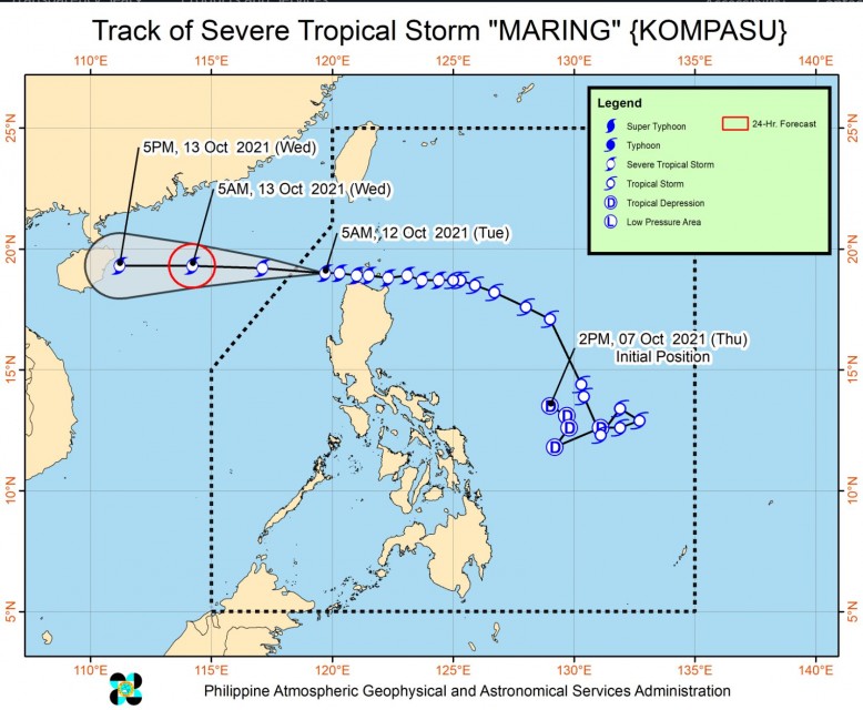
Based on all available data, the center of Maring was estimated to be over 230 km West of Calayan, Cagayan (19.0°N, 119.3°E).
It has maximum sustained winds of 100 km/h near the center, gustiness of up to 125 km/h, and central pressure of 975 hPa. It is moving westward at 25 km/h, which is much faster than Monday night’s 15 km/h.
-Areas under Tropical Cyclone Wind Signal-
Tropical cyclone wind signal no. 2 remain hoisted in these nine provinces in Northern Luzon:
Batanes, Cagayan including Babuyan Islands, the northern portion of Isabela (Palanan, Divilacan, Maconacon, Ilagan City, Tumauini, Cabagan, San Pablo, Santa Maria, Santo Tomas, Delfin Albano, Quirino, Gamu, Roxas, Mallig, Quezon), Apayao, Kalinga, Mountain Province, Abra, Ilocos Norte, and Ilocos Sur
Signal no. 1, on the other hand, are hoisted in these areas:
The rest of Isabela, Nueva Vizcaya, Quirino, Ifugao, Benguet, La Union, Pangasinan, Aurora, Nueva Ecija, Tarlac, Zambales, Pampanga, Bulacan, the northern portion of Bataan (Samal, Morong, Dinalupihan, Abucay, Orani, Hermosa), and the northern portion of Quezon (General Nakar, Infanta) including Polillo Islands
-Heavy to intense rains-
Today, Tuesday, Oct. 12, heavy to intense rains are highly likely over Ilocos Region, Benguet, Ifugao, Abra, and Mountain Province while moderate to heavy rains are highly likely over Zambales, Bataan, Tarlac, and the rest of Cordillera Administrative Region. Light to moderate with at times heavy rains are likely over Metro Manila, Cagayan Valley, and the rest Central Luzon.
PAGASA added that “under the influence of the Southwest Monsoon enhanced by Tropical Storm ‘MARING’, monsoon rains are possible over Western Visayas, Palawan, and Occidental Mindoro in the next 24 hours
Severe Tropical Storm “MARING” will continue to move westward over the West Philippine Sea throughout the forecast period. It is forecast to exit the Philippine Area of Responsibility (PAR) this morning or afternoon. Outside the PAR, “MARING” will maintain a westward heading and is likely to make landfall in the vicinity of Hainan, China tomorrow evening, PAGASA said in its bulletin.
(Eagle News Service)


