


Typhoon forecast to gradualy weaken into a severe tropical storm by Saturday, and exit PHL by Sunday
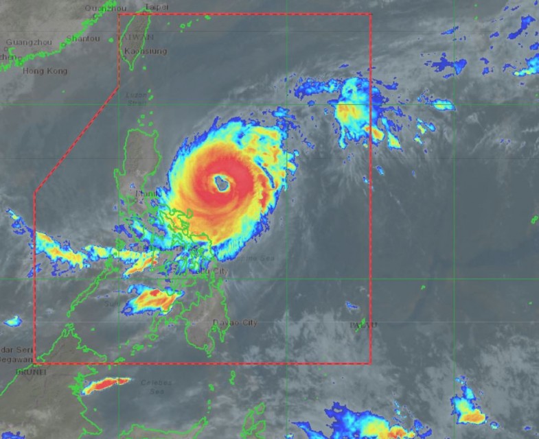
(Eagle News) Typhoon Bising (international name Surigae) has further weakened as it continues to move slowly northward with gusts of up to 215 kilometers per hour.
As of PAGASA’s 5 a.m. bulletin on Tuesday, April 20, only Catanduanes, eastern portion of Camarines Sur, and the northeastern portion of Albay in Luzon remain under tropical cyclone wind signal (TCWS) no. 2.
-Areas under cyclone wind signal:
The towns covered by the TCWS no. 2 are the following: Catanduanes, the eastern portion of Camarines Sur (Sagnay, San Jose, Lagonoy, Garchitorena, Presentacion, Caramoan), and the northeastern portion of Albay (Tiwi, Malinao, Tabaco City, Malilipot, Bacacay, Rapu-Rapu).
These are the areas covered by Signal no. 1 as the typhoon moved upward Luzon slowly:
In Luzon:
Batanes, Cagayan including Babuyan Islands, Isabela, Quirino, Apayao, the eastern portion of Kalinga (Pinukpuk, Rizal, Tabuk City), the extreme eastern portion of Mountain Province (Paracelis), the extreme eastern portion of Ifugao (Alfonso Lista), the northern portion of Aurora (Baler, Dipaculao, Dinalungan, Casiguran, Dilasag), the eastern portion of Quezon (Calauag, Guinayangan, Tagkawayan, Buenavista, San Narciso, San Andres) including Polillo Islands, Camarines Norte, the rest of Camarines Sur, the rest of Albay, Sorsogon, and the northern portion of Masbate (Aroroy, Masbate City, Baleno, Mobo, Uson, Palanas, Dimasalang) including Burias and Ticao Islands
In Visayas:
Northern Samar, the northern portion of Samar (Tagapul-An, Almagro, Santo Nino, Calbayog City, Santa Margarita, Gandara, Pagsanghan, Tarangnan, San Jorge, San Jose de Buan, Matuguinao), and the northern portion of Eastern Samar (Maslog, Can-Avid, Dolores, Oras, San Policarpo, Arteche, Jipapad)
As can be seen in PAGASA’s bulletin, no more areas in Mindanao are under any wind signal.
At 4:00 a.m. Tuesday, April 20, the typhoon’s center was located 505 km East of Infanta, Quezon, moving northward slowly, with maximum sustained winds of 175 km/h near the center and gustiness of up to 215 km/h
-Heavy to intense rains over Catanduanes-
Today, Tuesday, “heavy to intense rains will be experienced over Catanduanes” while “moderate to heavy rains” will be felt over the eastern portion of Camarines Sur and Rapu-Rapu Islands. Floods and rain-induced landslides can occur in these areas.
“Tropical cyclone winds of at least strong breeze to near gale in strength extend outward up to 500 km from the center of the typhoon. Destructive typhoon-force winds extend outward up to 110 km from the center of the typhoon,” PAGASA said.
-Signal no. 2 may be hoisted later in Cagayan, Isabela-
“Considering the uncertainty in the projected path of the typhoon over the next 48 hours, the possibility of hoisting Tropical Cyclone Wind Signal #2 over some areas in the eastern portion of Cagayan and Isabela is not ruled out at this time,” it said.
In the next 24 hours, the northeasterly wind flow enhanced by the typhoon will also bring strong breeze to near gale conditions with higher gusts over the rest of Northern Luzon and the rest of Aurora and Quezon that are not under any Tropical Cyclone Wind Signal (TCWS). Such conditions are more likely to occur in the coastal and mountainous areas.
-Forecast movement of typhoon Bising-
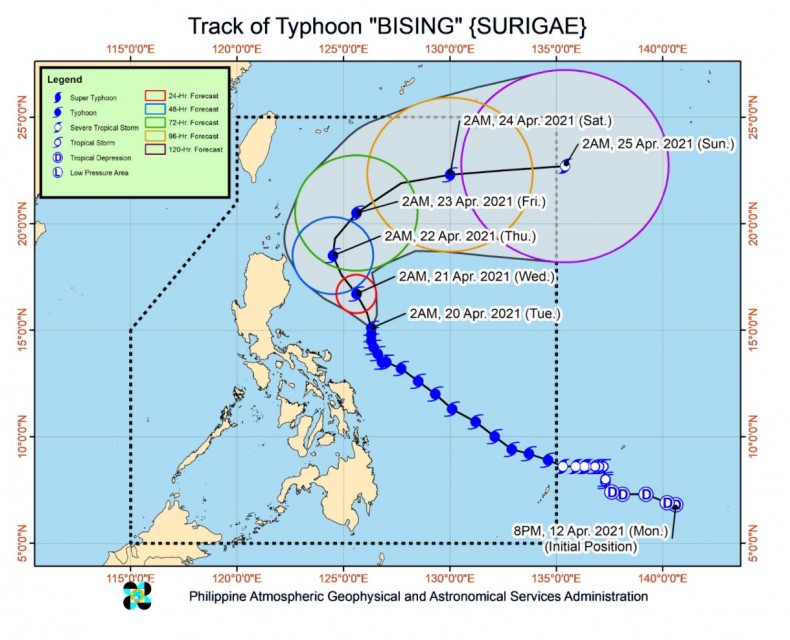
PAGASA forecasts typhoon “BISING” to move generally northward or north northwestward until tomorrow evening, Wednesday, April 21, or early morning Thursday, April 22. Afterwards, the typhoon will move northeastward from the landmass of Luzon throughout Thursday and east northeastward on Friday, April 23, and Saturday, April 24. The typhoon is projected to exit the Philippine Area of Responsibility on Sunday, April 25.
“BISING” is forecast to gradually weaken throughout the forecast period and may be downgraded to severe tropical storm by Saturday evening or Sunday early morning, PAGASA said.
(Eagle News Service)


