


PAGASA forecasts “Florita” to reach tropical storm category by Monday, August 22
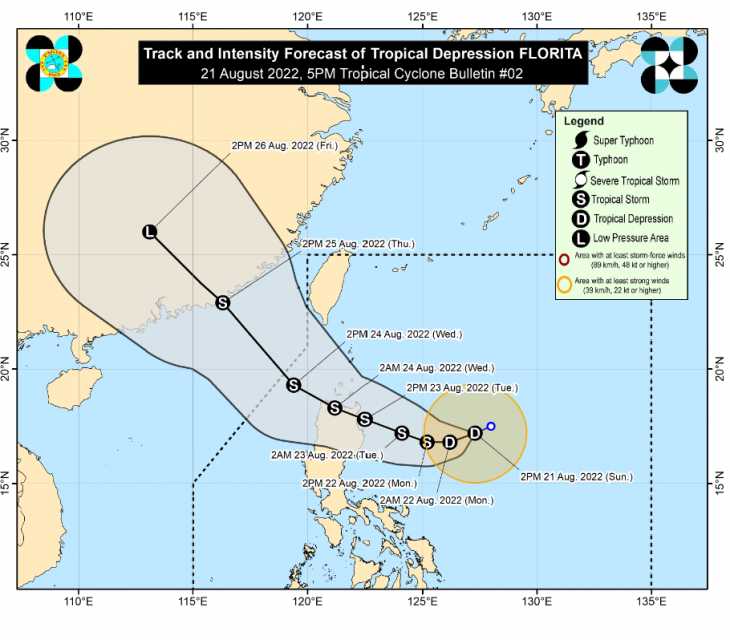
(Eagle News) – Tropical depression Florita has slightly intensified while moving west southwestward over the Philippine Sea east of Cagayan.
As of 5 p.m., Sunday, August 22, tropical cyclone wind signal no. 1 is in effect in the following areas in Luzon: the northern portion of Aurora (Dilasag), the eastern portion of Isabela (Dinapigue, Palanan, Divilacan, Maconacon, San Pablo, Cabagan, Tumauini, Ilagan City, San Mariano), and the eastern portion of Cagayan (Peñablanca, Baggao).
“FLORITA” is forecast to reach tropical storm category tomorrow morning or afternoon, Monday, August 22, and “may reach peak intensity of 75 km/h prior to making landfall on Tuesday morning or afternoon.
“Slight weakening is likely as it crosses the Northern Luzon, but it is forecast to remain within the tropical storm category,” PAGASA said in its 5 pm weather bulletin.
PAGASA said Tropical Depression “FLORITA” will continue moving generally west southwestward in the next 12 hours before turning westward tomorrow morning, then west northwestward by Tuesday towards Northern Luzon.
-Landfall by Tuesday in the vicinity of Cagayan or Isabela-
“On the forecast track, the center of this tropical cyclone is forecast to make landfall in the vicinity of Cagayan or northern portion of Isabela on Tuesday morning or afternoon,” PAGASA’s weather bulletin said.
Afterwards, the center of “FLORITA” will move west northwestward and cross several provinces in Northern Luzon before emerging over the West Philippine Sea by Wednesday early morning.
-Heavy rainfall-
PAGASA advises the public to expect heavy rainfall especially in areas in Luzon affected by the storm.
By tomorrow early morning through afternoon, August 22, light to moderate with at times heavy rains may prevail over Cagayan, Isabela, Batanes, and Aurora.
By Monday evening through Tuesday evening, “heavy to intense with at times torrential rains over Batanes, Cagayan, Isabela, Cordillera Administrative Region, and Ilocos Region. Light to moderate with at times heavy rains over Central Luzon and the rest of Cagayan Valley.”
“Under these conditions, scattered to widespread flooding (including flash floods) and rain-induced landslides are expected especially in areas that are highly or very highly susceptible to these hazard as identified in hazard maps, and in localities with significant antecedent rainfall,” PAGASA said.
The center of Florita’s eye was estimated based on all available data 540 km East of Tuguegarao City, Cagayan (17.1 °N, 126.8 °E ). It is moving West Southwestward, with maximum sustained winds of 55 km/h near the center and gustiness of up to 70 km/h.
It is foreast to be 480 km East of Tuguegarao City, Cagayan or 440 km East of Casiguran, Aurora. by Monday, Aug 22,at 2 a.m.. By 2 p.m., it is forecast to be 380 km East Southeast of Tuguegarao City, Cagayan or 335 km East of Casiguran, Aurora.
It is forecast to be outside the Philippine Area of Responsibility (PAR) by Thursday afternoon, Aug. 25.
(Eagle News Service)


