


(Eagle News) – Six provinces in Luzon have been placed under Tropical Cyclone Wind Signal No. 2 as of 5 a.m. today, Wednesday, Oct. 21, because of tropical storm Pepito (Saudel) which has crossed the rugged terrain of Northern Luzon and is now over the Lingayen Gulf.
The areas currently under Signal No. 2 are Ilocos Sur, La Union, Pangasinan, Benguet. Tarlac, and the northern portion of Zambales (Iba, Palauig, Masinloc, Candelaria, Santa Cruz, Botolan, Cabangan).
There are more areas under Signal No. 1 covering at least 14 provinces in Luzon. They are Ilocos Norte, Kalinga, Abra, Ifugao, Mountain Province, the southern portion of Isabela (Palanan, San Mariano, Benito Soliven, Naguilian, Gamu, Burgos, San Manuel, Aurora, Cabatuan, Luna, Reina Mercedes, Cauayan City, Dinapigue, San Guillermo, Angadanan, Alicia, San Mateo, Ramon, San Isidro, Echague, San Agustin, Jones, Santiago City, Cordon), Quirino, Nueva Vizcaya, Aurora, Nueva Ecija, Bulacan, Pampanga, the rest of Zambales, and Bataan.
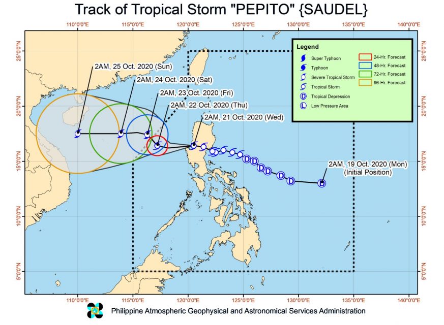
As of 4 a.m. today, the center of Tropical Storm “PEPITO” was estimated based on all available data at 40 km North Northwest of Dagupan City, Pangasinan, according to PAGASA.
The country’s weather bureau said “Pepito” is forecast to move generally westward over the West Philippine Sea today, before slowing down and turning northwestward tomorrow.
“It is forecast to exit the Philippine Area of Responsibility (PAR) tomorrow morning or afternoon. On the forecast track, ‘PEPITO’ will accelerate and turn westward beginning Friday towards the central portion of Vietnam,” PAGASA’s 5 a.m. weather bulletin said.
The storm’s intensity is forecast to “gradually intensify over the West Philippine Sea and may reach severe tropical storm category by tomorrow afternoon or evening.
“Pepito” will bring moderate to heavy rains over Batanes, Cagayan, Ilocos Norte, Pangasinan, La Union, Apayao, Benguet, Zambales, Bataan, Occidental Mindoro, and Calamian Islands.
Light to moderate with at times heavy rains will be experienced over Metro Manila and the rest of Luzon. Flooding (including flash floods) and rain-induced landslides may occur during heavy or prolonged rainfall especially in areas that are highly or very highly susceptible to these hazards. PAGASA Regional Services Divisions may issue local thunderstorm/rainfall advisories and heavy rainfall warnings as appropriate.
PAGASA said the storm will bring gale-force winds and high (strong to near gale) in areas under Tropical Cyclone Wind Signal (TCWS) no. 2 and no. 1, respectively.
“High to gale-force winds due to the northeasterly surface wind flow will also be experienced over the rest of northern Luzon, especially in coastal and mountainous areas,” it added.
(Eagle News Service)


