


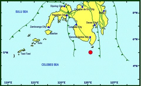
(Eagle News) — A magnitude 7.2 quake shook Sarangani in Davao Occidental, with its epicenter located at sea 53 kilometers southwest of Sarangani province at 4:23 a.m. Saturday, April 29.
According to the Philippine Institute of Volcanology and Seismology (PHIVOLCS), the quake had a depth of 57 kilometers, and was felt at various intensities in nearby areas as listed below:
Intensity 5 – General Santos City; Koronadal City; Santa Maria, Jose Abad Santos, Don Marcelino, Balot Island, Davao Occidental; Polomolok, Tupi, South Cotabato; Alabel, Malapatan, Glan, Sarangani; Palimbag, Sultan Kudarat
Intensity 4- Davao City; Cotabato City; Zamboanga City
Intensity 3- Cagayan De Oro City
Intensity 2- Kidapawan City
Instrumental Intensities:
Intensity 5- General Santos City
Intensity 4- Zamboanga City
Intensity 3 – Cotabato City
In General City, power was immediately cut off but was also immediately restored.
PHIVOLCS initially issued a tsunami warning at 5:03 a.m., telling residents near the seas or coastal areas to watch out for possible “wave heights of less than one meter above the normal tide levels.”
This warning had since been lifted, with Phivolcs saying that the threat had passed.


